Loughborough
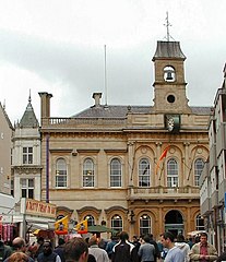
(c) Chris J Dixon, CC BY-SA 2.0 Ratusz w dzień targowy | |
| Państwo | |
|---|---|
| Kraj | |
| Hrabstwo | Leicestershire |
| Populacja (2001) • liczba ludności | 55 258 |
| Nr kierunkowy | 01509 |
| Kod pocztowy | LE11 |
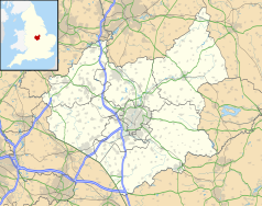
Położenie na mapie Leicestershire Contains Ordnance Survey data © Crown copyright and database right, CC BY-SA 3.0 | |
Położenie na mapie Wielkiej Brytanii (c) Karte: NordNordWest, Lizenz: Creative Commons by-sa-3.0 de | |
| Strona internetowa | |
| Portal | |
Loughborough (wym. /ˈlʌfb(ə)rə/) – miasto w Anglii (Leicestershire). Położone jest 15,9 km od miasta Leicester i 159,4 km na północ od Londynu[1]. W 2001 roku miasto liczyło 55 258 mieszkańców[2].
Loughborough jest wspomniane w Domesday Book (1086) jako Locte/Lucteburne[3]. Rozwinięte przemysły: dziewiarski, obuwniczy, farmaceutyczny, metalowy[4].
Miasta partnerskie
Przypisy
- ↑ Distance from LOUGHBOROUGH [SK537196] (ang.). GENUKI. [dostęp 2016-09-19].
- ↑ KS01 Usual resident population: Census 2001, Key Statistics for urban areas (ang.). Office for National Statistics. [dostęp 2016-09-19]. [zarchiwizowane z tego adresu (2004-07-23)].
- ↑ Leicestershire H-R (ang.). The Domesday Book online. [dostęp 2016-09-19].
- ↑ Loughborough, [w:] Encyklopedia PWN [online] [dostęp 2021-07-22].
Media użyte na tej stronie
(c) Karte: NordNordWest, Lizenz: Creative Commons by-sa-3.0 de
Location map of the United Kingdom
Flag of England. Saint George's cross (a red cross on a white background), used as the Flag of England, the Italian city of Genoa and various other places.
The Flag of India. The colours are saffron, white and green. The navy blue wheel in the center of the flag has a diameter approximately the width of the white band and is called Ashoka's Dharma Chakra, with 24 spokes (after Ashoka, the Great). Each spoke depicts one hour of the day, portraying the prevalence of righteousness all 24 hours of it.
(c) Chris J Dixon, CC BY-SA 2.0
Loughborough Town Hall. A busy scene on market day.
Contains Ordnance Survey data © Crown copyright and database right, CC BY-SA 3.0
Map of Leicestershire, UK with the following information shown:
- Administrative borders
- Coastline, lakes and rivers
- Roads and railways
- Urban areas
Equirectangular map projection on WGS 84 datum, with N/S stretched 160%
Geographic limits:
- West: 1.80W
- East: 0.50W
- North: 53.00N
- South: 52.36N


