Loveland (Ohio)
| |||
| Państwo | |||
|---|---|---|---|
| Stan | |||
| Hrabstwo | |||
| Burmistrz | Rob Weisgerber | ||
| Powierzchnia | 12,2 km² | ||
| Wysokość | 183[1] m n.p.m. | ||
| Populacja (2010) • liczba ludności • gęstość |
| ||
| Nr kierunkowy | 513 | ||
| Kod pocztowy | 45140 | ||
| Strona internetowa | |||
| Portal | |||
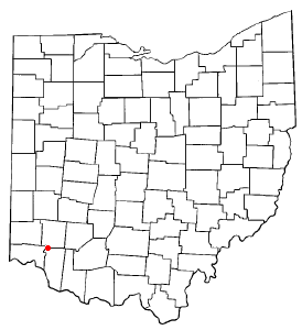
Loveland – miasto w Stanach Zjednoczonych, w południowo-zachodniej części stanu Ohio, w hrabstwie Hamilton. W 2000 roku liczba ludności wynosiła 11 771[2]. Miasto zostało nazwane na cześć Jamesa Lovelanda. W Loveland znajduje się 16 parków miejskich.
Geografia
Współrzędne geograficzne miasta to 39°16′8″ szerokości północnej i 84°16′13″ długości zachodniej (39,268759, -84,270397). Według United States Census Bureau, powierzchnia miasta wynosi 12,2 km², z czego 12,0 km² to ląd, a 0,2 km² to woda. Woda stanowi 1,28% powierzchni.
Demografia
Według spisu powszechnego z roku 2000, miasto zamieszkuje 11 677 osób i 3 224 rodzin. Gęstość zaludnienia wynosi 969,6/km². W mieście jest 4497 gospodarstw domowych i 4 653 jednostek mieszkalnych o zagęszczeniu 386,4 jednostek/km². 95,66% mieszkańców należy do rasy białej, 1,56% to osoby należące do rasy czarnej lub Afroamerykanie, 0,05% to rdzenni Amerykanie lub Indianie, 1,05% Azjaci, 0,42% do innej rasy, zaś 1,26% do dwóch lub więcej ras. 1,12% ludności to Latynosi lub osoby pochodzenia hiszpańskiego.
Linki zewnętrzne
- Historia miasta. lovelandchamber.org. [zarchiwizowane z tego adresu (2005-02-12)]. (ang.)
Przypisy
- ↑ Feature Detail Report for: Loveland, Ohio (ang.). The Geographic Names Information System (GNIS). [dostęp 2017-06-30].
- ↑ a b Loveland, Ohio Population Census 2010 and 2000 (ang.). CensusViewer. [dostęp 2017-06-30].
Media użyte na tej stronie
Autor: Uwe Dedering, Licencja: CC BY-SA 3.0
Location map of the USA (without Hawaii and Alaska).
EquiDistantConicProjection:
Central parallel:
* N: 37.0° N
Central meridian:
* E: 96.0° W
Standard parallels:
* 1: 32.0° N
* 2: 42.0° N
Made with Natural Earth. Free vector and raster map data @ naturalearthdata.com.
Formulas for x and y:
x = 50.0 + 124.03149777329222 * ((1.9694462586094064-({{{2}}}* pi / 180))
      * sin(0.6010514667026994 * ({{{3}}} + 96) * pi / 180))
y = 50.0 + 1.6155950752393982 * 124.03149777329222 * 0.02613325650382181
      - 1.6155950752393982  * 124.03149777329222 *
     (1.3236744353715044  - (1.9694462586094064-({{{2}}}* pi / 180))
      * cos(0.6010514667026994 * ({{{3}}} + 96) * pi / 180))
The flag of Navassa Island is simply the United States flag. It does not have a "local" flag or "unofficial" flag; it is an uninhabited island. The version with a profile view was based on Flags of the World and as a fictional design has no status warranting a place on any Wiki. It was made up by a random person with no connection to the island, it has never flown on the island, and it has never received any sort of recognition or validation by any authority. The person quoted on that page has no authority to bestow a flag, "unofficial" or otherwise, on the island.
Autor: R.P. Piper, Licencja: CC BY 2.0
A panorama overlooking Historic Downtown Loveland, Ohio, United States, taken near the Bible Believer's Baptist Church.
In the center is the Five Points intersection of Broadway Street (lower and upper left), East Broadway Street (lower right), North Second Street (center right), and South Second Street (center left). The intersection has since been reconfigured so that South Second Street empties directly into Broadway Street and the remaining four ways meet at a traffic light.
In the distance is West Loveland Avenue, the main street of Historic Downtown Loveland, seen in Historic Downtown Loveland, Ohio.jpg. Several buildings in the center have been razed to make way for a four-story apartment complex.The city flag of Loveland, Ohio, United States, vectorized based on photographs of two physical flags at Loveland City Hall, one of nylon in the council chamber and another presumably of felt framed above a doorway in the main lobby. The two flags slightly differ in the number of veins in some of the leaflets and the shape of the scroll. Colors are from Template:Tincture; the actual blue, red, gold, and green are slightly darker.
Autor: Alexrk2, Licencja: CC BY 3.0
Ta mapa została stworzona za pomocą GeoTools.
(c) Catbar at en.wikipedia, CC-BY-SA-3.0
County map of Ohio, with a red dot at Loveland, which is located in three counties.
This is a locator map showing Warren County in Ohio. For more information, see Commons:United States county locator maps.


