Loxstedt
| gmina | |||
 | |||
| |||
| Państwo | |||
|---|---|---|---|
| Kraj związkowy | |||
| Powiat | Cuxhaven | ||
| Powierzchnia | 141,24 km² | ||
| Wysokość | 1 m n.p.m. | ||
| Populacja (31.12.2008) • liczba ludności | 16 110 | ||
| • gęstość | 103 os./km² | ||
| Numer kierunkowy | 04703, 0471, 04740, 04744 | ||
| Kod pocztowy | 27612 | ||
| Tablice rejestracyjne | CUX | ||
Adres urzędu: Am Wedenberg 1027612 Loxstedt | |||
| Położenie na mapie powiatu | |||
| 53°28′N 8°39′E/53,466667 8,650000 | |||
| Strona internetowa | |||
| Portal | |||
Loxstedt – gmina samodzielna (niem. Einheitsgemeinde) w Niemczech, w kraju związkowym Dolna Saksonia, w powiecie Cuxhaven. W 2008 r. liczyła 16 110 mieszkańców.
Współpraca
Media użyte na tej stronie
Autor: Mark Michaelis, Licencja: CC BY-SA 2.0
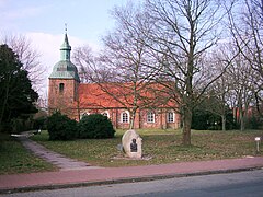
St. Marienkirche in Loxstedt, 2004
(c) NordNordWest, TUBS & Hagar66, CC BY-SA 3.0
|
|
|
|
|
|
|
|


