Luapula
 | |
| Kontynent | |
|---|---|
| Państwo | |
| Rzeka | |
| Długość | 1500 km |
| Źródło | |
| Miejsce | Bangweulu |
| Współrzędne | |
| Ujście | |
| Recypient | |
| Miejsce | Mweru |
| Współrzędne | |
Położenie na mapie Zambii (c) Karte: NordNordWest, Lizenz: Creative Commons by-sa-3.0 de | |
Luapula – rzeka w Zambii oraz Demokratycznej Republice Konga, prawy dopływ Lualaby. Długość 1500 km.
Rzeka ta jest żeglowna odcinkami.
Na rzece znajdują się liczne wodospady.
Media użyte na tej stronie
(c) Karte: NordNordWest, Lizenz: Creative Commons by-sa-3.0 de
Location map of Zambia
The national flag of the Democratic Republic of the Congo. Created according to the 2006 constitution : Son emblème est le drapeau bleu ciel, orné d’une étoile jaune dans le coin supérieur gauche et traversé en biais d’une bande rouge finement encadrée de jaune. (Its symbol is a sky blue flag, decorated with a yellow star in the upper left corner and crossed in the diagonal by a red strip with thin yellow borders) It seems to be identical, except for a lighter field hue, to the 1966–1971 flag.
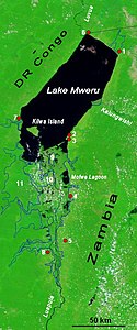
The lower Luapula River, its delta where it enters Lake Mweru, and Mweru's outlet, the Luvua River going on north to the Lualaba and Congo rivers. Water shows up as black in this false-colour NASA satellite image. The extent of the Luapula Swamps is shown by the solid blue line, and the extent of the floodplain is shown as a dotted line. The towns are, in Zambia: 1 Chiengi, 2 Kashikishi, 3 Nchelenge, 4 Mwansabombwe, 5 Mwense; in DR Congo: 6 Pweto, 7 Kilwa, 8 Kasenga. Other features: 9 Chisenga Island, 10 the largest swamp island (in DR Congo), 11 the main floodplain.


