Lurgan
| ||
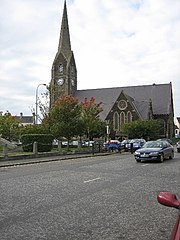
(c) Brian Shaw, CC BY-SA 2.0 kościół w Lurgan | ||
| Państwo | ||
| Prowincja | ||
| Region | Armagh | |
| Nr kierunkowy | 028 | |
Położenie na mapie Wielkiej Brytanii (c) Karte: NordNordWest, Lizenz: Creative Commons by-sa-3.0 de | ||
| Strona internetowa | ||
| Portal | ||
Lurgan (irlandzki: An Lorgain) – miasto w Irlandii Północnej, leżące w hrabstwie Armagh. Miasto liczy ponad 23 000 mieszkańców.
Lurgan znajduje się około 30 km na południowy zachód od Belfastu, z którym połączony jest zarówno autostradą M1 jak i linią kolejową[1].
Historia
Nazwa miasta Lurgan pochodzi od irlandzkiego słowa An Lorgain, co oznacza długi grzbiet, goleń.Miasto Lurgan miało wcześniej kilka nazw: Lorgain Chlann Bhreasail i Lorgain Bhaile Mhic Cana.
od XVII rozpoczął się proces Plantacji Ulsteru, czyli wysiedlanie Katolickich Irlandczyków i zasiedlanie ich miejsce angielskich protestantów oraz szkockich prezbiterianie.
w XX wieku w mieście dominował przemysł tekstylny, w którym zatrudnienie znalazło większość mieszkańców, aż do końca wieku[2].
Linki zewnętrzne
Przypisy
- ↑ http://maps.msn.com/(cgxnej455qpgxeu5vurxtejz)/map.aspx?L=WLD&C=54.46573%2c-6.33843&A=286.66667&P=%7C4C21%7C&TI=Lurgan%2c+Northern+Ireland%2c+United+Kingdom MSN World Atlas
- ↑ The Rise and Development of Portadown, www.craigavonhistoricalsociety.org.uk [dostęp 2017-11-25] [zarchiwizowane z adresu 2017-11-22].
Media użyte na tej stronie
(c) Karte: NordNordWest, Lizenz: Creative Commons by-sa-3.0 de
Location map of the United Kingdom
Ulster Banner is a heraldic banner taken from the former coat of arms of Northern Ireland. It was used by the Northern Ireland government in 1953-1973 with Edwardian crown since coronation of Queen Elizabeth II, based earlier design with Tudor Crown from 1924. Otherwise known as the Ulster Flag, Red Hand of Ulster Flag, Red Hand Flag.
Ulster Banner is a heraldic banner taken from the former coat of arms of Northern Ireland. It was used by the Northern Ireland government in 1953-1973 with Edwardian crown since coronation of Queen Elizabeth II, based earlier design with Tudor Crown from 1924. Otherwise known as the Ulster Flag, Red Hand of Ulster Flag, Red Hand Flag.
(c) Brian Shaw, CC BY-SA 2.0
Shankill Parish Church, Lurgan. In 1718, the Vestry of Shankill (in Irish sean kill=old church)agree to build a new Parish Church in the centre of Lurgan. This is probably a later one, as the spire was completed in 1831.
Autor: NordNordWest, Licencja: CC BY-SA 3.0
Location map of Northern Ireland


