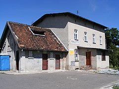
Małdyty (stacja kolejowa)
 | |
| Państwo | |
|---|---|
| Miejscowość | |
| Poprzednie nazwy | Maldeuten |
| Dane techniczne | |
| Liczba peronów | 2 |
| Liczba krawędzi peronowych | 3 |
| Kasy |
|
| Linie kolejowe | |
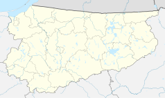
Położenie na mapie Polski (c) Karte: NordNordWest, Lizenz: Creative Commons by-sa-3.0 de | |
| Portal | |
Małdyty – stacja kolejowa w Małdytach, w województwie warmińsko-mazurskim, w Polsce.
W roku 2017 stacja obsługiwała 100–149 pasażerów na dobę[1].
Przypisy
- ↑ Największe i najmniejsze stacje w Polsce. W: utk.gov.pl [on-line]. [dostęp 2019-12-18].
Linki zewnętrzne
- Małdyty w Atlasie Kolejowym Polski, Czech i Słowacji – www.atlaskolejowy.net
- Małdyty w Ogólnopolskiej Bazie Kolejowej – bazakolejowa.pl
- Małdyty w internetowym rozkładzie jazdy PKP – rozklad-pkp.pl (odjazdy)
| Małdyty | ||
| Linia 220 Olsztyn Główny – Bogaczewo | ||
odległość: 7,267 km | odległość: 6,558 km | |
| Linia 222 Małdyty – Malbork | ||
odległość: 4,722 km | ||
Media użyte na tej stronie
Poland adm location map.svg
(c) Karte: NordNordWest, Lizenz: Creative Commons by-sa-3.0 de
Location map of Poland
(c) Karte: NordNordWest, Lizenz: Creative Commons by-sa-3.0 de
Location map of Poland
Warmian-Masurian Voivodeship location map.svg
Autor: SANtosito, Licencja: CC BY-SA 4.0
Location map of Warmian-Masurian Voivodeship. Geographic limits of the map:
Autor: SANtosito, Licencja: CC BY-SA 4.0
Location map of Warmian-Masurian Voivodeship. Geographic limits of the map:
- N: 54.52 N
- S: 53.07 N
- W: 19.05 E
- E: 22.95 E
BSicon KHSTl.svg
head stop, track to the left
head stop, track to the left
BSicon KHSTaq.svg
head stop, track to the left
head stop, track to the left
BSicon STRq.svg
Straight line aqross (according to naming convention, name + modifier)
Straight line aqross (according to naming convention, name + modifier)
BSicon BHFq.svg
station at track aqross
station at track aqross
BSicon KHSTr.svg
head stop, track to the right
head stop, track to the right
BSicon KHSTeq.svg
head stop, track to the right
head stop, track to the right
BSicon KBHFl.svg
head station, track to the left
head station, track to the left
BSicon KBHFaq.svg
head station, track to the left
head station, track to the left
BSicon exSTRq.svg
Straight line aqross (according to naming convention, name + modifier)
Straight line aqross (according to naming convention, name + modifier)
BSicon exKHSTr.svg
ex terminal stop, track to the right
ex terminal stop, track to the right
BSicon exKHSTeq.svg
ex terminal stop, track to the right
ex terminal stop, track to the right
Ostróda County location map02.svg
Autor: SANtosito, Licencja: CC BY-SA 4.0
Location map of Ostróda County with urbanized area highlighted. Geographic limits of the map:
Autor: SANtosito, Licencja: CC BY-SA 4.0
Location map of Ostróda County with urbanized area highlighted. Geographic limits of the map:
- N: 54.10 N
- S: 53.35 N
- W: 19.50 E
- E: 22.30 E


