Maarssen
| |||||
 | |||||
| Państwo | |||||
| Prowincja | |||||
| Powierzchnia | 30,86 km² | ||||
| Populacja (2007) • liczba ludności • gęstość | 39 363 1447 os./km² | ||||
| Nr kierunkowy | 0346 | ||||
| Kod pocztowy | 3601-3608 | ||||
| Strona internetowa | |||||
Maarssen – miasto w środkowej Holandii, w prowincji Utrecht, nad rzeką Vecht. Dawniej samodzielna gmina, od 1 stycznia 2011 wchodzi w skład gminy Stichtse Vecht.
Liczba mieszkańców: 39 363 (1 stycznia 2007).
Media użyte na tej stronie
Autor: Foto genomen door user:SanderK. Picture by user:SanderK., Licencja: CC BY-SA 2.5
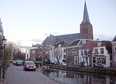
Schippersgracht, Maarssen(-dorp), Nederland. Schippersgracht, Maarssen, the Netherlands.
Flag of the Dutch municipality of Maarssen
Autor: Erik Frohne, Licencja: CC BY-SA 3.0
Location map of province Utrecht in the Netherlands
Equirectangular projection, N/S stretching 163 %. Geographic limits of the map:
- N: 52.40° N
- S: 51.90° N
- W: 4.70° E
- E: 5.70° E
Coat of arms of the former Dutch municipality of Maarssen.


