Maasdriel
| |||||
 | |||||
| Państwo | |||||
| Prowincja | |||||
| Burmistrz | Gerd Prick (p.o., od 2012)[1] | ||||
| Powierzchnia | 75,46 km² | ||||
| Populacja (2014) • liczba ludności • gęstość | 24 197 [2] 367 os./km² | ||||
| Nr kierunkowy | 0418, 0487, 073 | ||||
| Kod pocztowy | 5320-5321, 5324-5325, 5327-5328, 5330-5331, 5333-5335, 6624 | ||||
| Strona internetowa | |||||
Maasdriel - gmina w prowincji Geldria w Holandii. W 2014 roku populacja wyniosła 24 197 mieszkańców. Siedziba gminy znajduje się w Kerkdriel
Przez gminę przechodzi autostrada A2 oraz drogi prowincjonalne N322, N831 oraz N832.
Miejscowości
- Alem (640)
- Ammerzoden (3500)
- Hedel (4850)
- Heerewaarden (1500)
- Hoenzadriel (260)
- Hurwenen (840)
- Kerkdriel (7300)
- Rossum (2700)
- Velddriel (1565)
- Well (1015)
- Wellseind
oraz przysiółki: Californië · Doorning · Rome · Sint Andries · Slijkwell · Veluwe · Voorne · Wordragen
Przypisy
- ↑ Brabands Dagblad: Gerd Prick nieuwe waarnemer in Maasdriel (niderl.). 2012-12-04. [dostęp 2014-07-09].
- ↑ Aktualna liczba mieszkańców miasta (nl) [dostęp 26 kwietnia 2014]
Media użyte na tej stronie
Coat of arms of Maasdriel (Netherlands).
Flag of Maasdriel, in Gelderland province, the Netherlands.
Autor: Vincent van Zeijst, Licencja: CC BY-SA 3.0
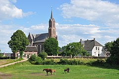
Alem, a village within the municipality Maasdriel (Gelderland province, Netherlands), with the Saint Hubertus church (built in 1873, Roman Catholic).
Autor: Erik Frohne, Licencja: CC BY-SA 3.0
Location map of province Gelderland in the Netherlands
Equirectangular projection, N/S stretching 163 %. Geographic limits of the map:
- N: 52.522° N
- S: 51.731° N
- W: 4.989° E
- E: 6.834° E


