Madhya Pradesh
| stan | |
 Ruiny Kapoor Talao w Mandu | |
| Państwo | |
|---|---|
| Siedziba | Bhopal |
| Kod ISO 3166-2 | IN-MP |
| Gubernator | Rameshwar Thakur |
| Premier | Shivraj Singh Chauhan |
| Powierzchnia | 308 144 km² |
| Populacja (2011) • liczba ludności | 72 597 565[1] |
| • gęstość | 235,6 os./km² |
| Języki urzędowe | hindi |
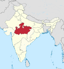
Położenie na mapie Indii | |
| Strona internetowa | |
Madhya Pradesh (hindi मध्य प्रदेश, trb.: Madhja Pradeś, trl.: Madhya Pradeś; ang. Madhya Pradesh) – stan w środkowych Indiach, który był największym stanem indyjskim do 1 listopada 2000 r., kiedy to został wydzielony z jego terytorium nowy stan Chhattisgarh. Madhya Pradesh graniczy ze stanami Uttar Pradesh, Chhattisgarh, Maharashtra, Gujarat i Radżastan.
Gospodarka
Jest to stan o dominującej roli rolnictwa w gospodarce, występują tu czarne ziemie o podłożu wulkanicznym. Uprawia się: bawełnę (co sprawiło, że w regionie rozwinął się przemysł tekstylny), a także pszenicę, trzcinę cukrową, soję, ryż. Występuje też drobne rzemiosło i słabo rozwinięty przemysł maszynowy i samochodowy.
Podział administracyjny
Madhja Pradeś dzieli się na następujące dystrykty:
Dystrykty Bhopal:
Dystrykty Gwalior:
- Ashoknagar
- Datia
- Guna
- Gwalior
- Shivpuri
Dystrykty Chambal:
- Bhind
- Morena
- Sheopur
Dystrykty Indore:
Dystrykty Jabalpur:
- Balaghat
- Chhindwara
- Dindori
- Jabalpur
- Katni
- Mandla
- Narsinghpur
- Seoni
Dystrykty Rewa:
- Anuppur
- Rewa
- Satna
- Shahdol
- Sidhi
- Umaria
Dystrykty Sagar:
- Chhatarpur
- Damoh District
- Panna District
- Sagar District
- Tikamgarh District
Dystrykty Ujjain:
Przypisy
- ↑ 3. Size, Growth Rate and Distribution of Population, [w:] 2011 Census of India, Office of the Registrar General & Census Commissioner, India [dostęp 2019-08-02] [zarchiwizowane z adresu 2019-05-31].
Linki zewnętrzne
Media użyte na tej stronie
The Flag of India. The colours are saffron, white and green. The navy blue wheel in the center of the flag has a diameter approximately the width of the white band and is called Ashoka's Dharma Chakra, with 24 spokes (after Ashoka, the Great). Each spoke depicts one hour of the day, portraying the prevalence of righteousness all 24 hours of it.
Autor: Bernard Gagnon, Licencja: CC BY-SA 3.0
Ruins on the north of Kapoor Talao, Mandu, India
Autor: TUBS
Location of state XY (see filename) in India


