Madikeri
| ||
| Państwo | ||
| Stan | Karnataka | |
| Dystrykt | Kodagu | |
| Wysokość | 1525 m n.p.m. | |
| Populacja (2001) • liczba ludności | 32286 | |
| Nr kierunkowy | +08 27 | |
| Kod pocztowy | 571 201 | |
| Tablice rejestracyjne | KA-12 | |
Położenie na mapie Indii | ||
Madikeri (język kannada: ಮಡಿಕೇರಿ; dawniej także Mercara) – miasto w indyjskim stanie Karnataka. Stolica dystryktu Kodagu. Obecna nazwa miasta jest skrótem pierwotnej Muddu radźa keri, dosłownie "miasto króla Muddu' który panował w latach 1633-1687[1].
Przypisy
- ↑ Coorg.com - Your Guide to Coorg, coorg.com [dostęp 2017-12-23] [zarchiwizowane z adresu 2009-04-26] (ang.).
Media użyte na tej stronie
Autor:
- Karnataka_locator_map.svg: by User:Planemad
- derivative work: User:Nayvik
Location map of Karnataka Geographic limits of the map:
- 18.53°N
- 11.48°N
- 73.66°E
- 78.62°E
(c) Uwe Dedering z niemieckiej Wikipedii, CC BY-SA 3.0
Location map of India.
Equirectangular projection. Strechted by 106.0%. Geographic limits of the map:
- N: 37.5° N
- S: 5.0° N
- W: 67.0° E
- E: 99.0° E
The Flag of India. The colours are saffron, white and green. The navy blue wheel in the center of the flag has a diameter approximately the width of the white band and is called Ashoka's Dharma Chakra, with 24 spokes (after Ashoka, the Great). Each spoke depicts one hour of the day, portraying the prevalence of righteousness all 24 hours of it.
City of Madikeri in Karnataka, India.
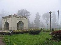
Raja seat at Madikeri, Photo taken by author himself


