Maizuru
| |||||||
 | |||||||
| Państwo | |||||||
|---|---|---|---|---|---|---|---|
| Prefektura | |||||||
| Wyspa | |||||||
| Region | |||||||
| Burmistrz | Akira Saitō | ||||||
| Powierzchnia | 342,15 km² | ||||||
| Populacja (2005) • liczba ludności • gęstość |
| ||||||
| Symbole japońskie | |||||||
| Drzewo | |||||||
| Kwiat | |||||||
| Strona internetowa | |||||||
| Portal | |||||||
Maizuru (jap. 舞鶴市 Maizuru-shi) – miasto w Japonii, w prefekturze Kioto, port nad Morzem Japońskim.
Gospodarka
W mieście rozwinął się przemysł włókienniczy, budowy statków rybackich, drzewny, szklarski oraz chemiczny[1].
Historia
Status miasta uzyskało w 1943, jego rozwój był związany z budową w 1901 portu morskiego, który odegrał później znaczną rolę w wojnie rosyjsko-japońskiej oraz II wojnie światowej.
Miasta partnerskie
Przypisy
- ↑ a b Maizuru, [w:] Encyklopedia PWN [online] [dostęp 2021-07-24].
Media użyte na tej stronie
The Flag of India. The colours are saffron, white and green. The navy blue wheel in the center of the flag has a diameter approximately the width of the white band and is called Ashoka's Dharma Chakra, with 24 spokes (after Ashoka, the Great). Each spoke depicts one hour of the day, portraying the prevalence of righteousness all 24 hours of it.
Emblem of Maizuru, Kyoto
Autor: Maximilian Dörrbecker (Chumwa), Licencja: CC BY-SA 3.0
Location map of Japan
Equirectangular projection.
Geographic limits to locate objects in the main map with the main islands:
- N: 45°51'37" N (45.86°N)
- S: 30°01'13" N (30.02°N)
- W: 128°14'24" E (128.24°E)
- E: 149°16'13" E (149.27°E)
Geographic limits to locate objects in the side map with the Ryukyu Islands:
- N: 39°32'25" N (39.54°N)
- S: 23°42'36" N (23.71°N)
- W: 110°25'49" E (110.43°E)
- E: 131°26'25" E (131.44°E)
Autor: 663highland, Licencja: CC BY 2.5
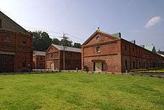
Maizuru Red Brick Warehouses in Maizuru, Kyoto prefecture, Japan
Flag of Maizuru, Kyoto


