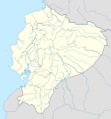
Manta (Ekwador)
| |||||
 | |||||
| Państwo | |||||
| Prowincja | |||||
| Kanton | Manta | ||||
| Burmistrz | Jaime Estrada Bonilla | ||||
| Powierzchnia | 60,49 km² | ||||
| Populacja (2013) • liczba ludności | 218 974[1] | ||||
| Nr kierunkowy | 593 5 | ||||
| Kod pocztowy | EC130850 | ||||
| Strona internetowa | |||||
Manta – miasto w zachodnim Ekwadorze, nad Oceanem Spokojnym, położone w prowincji Manabí. Około 200 tys. mieszkańców.
Miasto ucierpiało wskutek trzęsienia ziemi w roku 2016[2].
W mieście rozwinął się przemysł rybny oraz drzewny[3].
Miasta partnerskie
Przypisy
- ↑ https://archive.is/20130428141050/http://www.world-gazetteer.com/wg.php?x=&men=gpro&lng=en&des=wg&geo=-67&srt=pnan&col=abcdefghinoq&msz=1500&pt=c&va=&geo=320553928
- ↑ Fiscalía de Ecuador publica lista parcial de fallecidos: 86 en Manta; 22 en Canoa; 10 en Bahía; 76 Pedernales (hiszp.). UNIVERSO, 2016-04-18.
- ↑ Manta, [w:] Encyklopedia PWN [online] [dostęp 2021-07-24].
Media użyte na tej stronie
Made by author of Xramp, first uploaded by Denelson83 as Flag of Ecuador.svg, modifications by Husunqu.
The flag of Navassa Island is simply the United States flag. It does not have a "local" flag or "unofficial" flag; it is an uninhabited island. The version with a profile view was based on Flags of the World and as a fictional design has no status warranting a place on any Wiki. It was made up by a random person with no connection to the island, it has never flown on the island, and it has never received any sort of recognition or validation by any authority. The person quoted on that page has no authority to bestow a flag, "unofficial" or otherwise, on the island.
Autor: David C. S., Licencja: CC BY-SA 4.0
Coat of arms of Manta City (Ecuador)
Autor: HansenBCN, Licencja: CC BY-SA 3.0
Bandera de Manabí, Ecuador.
Ejemplares: [1]
[2]


