Mapa z Hereford
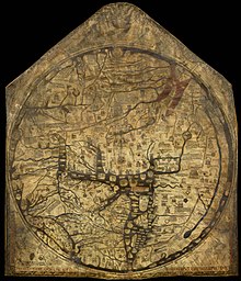
Mapa z Hereford – średniowieczna mapa świata (tzw. mappa mundi) stworzona około 1300 roku w schemacie O i T (orbis terrae – koło świata). Autorstwo przypisywane jest "Richardowi z Haldingham i Lafford".
W roku 2007 została wpisana na listę UNESCO Pamięć Świata[1].
Charakterystyka
Namalowana na pergaminie z cielęcej skóry, o wymiarach 158/138 cm, przy użyciu czarnego atramentu i kolorowych barwników. W centrum mapy znajduje się Jerozolima, wschód został umieszczony na górze, gdzie przedstawiono Ogród Edenu.
Nazwy kontynentów Europa i Afryka zostały prawdopodobnie pomyłkowo zamienione (Europa została podpisana jako Afryka, analogicznie Afryka została opisana błędnie). Mapa została oparta na starszych źródłach, jest dość podobna do mapy z Ebstorf, mapy Psaltera i mapy Sawleya. W trakcie jej tworzenia autor nie dysponował pełnym poziomem wiedzy geograficznej jemu współczesnych.
Mapa z Hereford jest największą zachowaną średniowieczną mapą, przechowywana jest przez Katedrę w Hereford w Anglii.
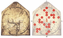
Lokalizacje na mapie
- 0 – W centrum mapy Jerozolima (z narysowanym krzyżem nad miastem).
- 1 – Raj, otoczony przez mur i ognisty krąg.
- 2 – Ganges i jego delta.
- 3 – Baśniowa wyspa Taphana (może być to Sri Lanka lub Sumatra).
- 4 – Rzeki Indus i Tygrys.
- 5 – Morze Kaspijskie, ziemia Goga i Magoga
- 6 – Babilon i Eufrat.
- 7 – Zatoka Perska.
- 8 – Morze Czerwone.
- 9 – Arka Noego.
- 10 – Morze Martwe, Sodoma i Gomora, rzeka Jordan, wypływająca z morza Galilejskiego.
- 11 – Egipt i Nil
- 12 – Rzeka Nil (lub możliwe przedstawienie brzegu fikcyjnego oceanu).
- 13 – Morze Azowskie, rzeki Don i Dniepr; (powyżej Złote runo).
- 14 – Konstantynopol; delta Dunaju.
- 15 – Morze Egejskie.
- 16 – Delta Nilu z latarnią morską w Aleksandrii.
- 17 – Mityczny norweski Gansmir.
- 18 – Grecja z górą Olimp, Atenami i Koryntem.
- 19 – Błędnie umieszczona Kreta z labiryntem Minotaura.
- 20 – Morze Adriatyckie; Włochy z zaznaczonym Rzymem.
- 21 – Sycylia i Kartagina.
- 22 – Szkocja.
- 23 – Anglia.
- 24 – Irlandia.
- 25 – Baleary.
- 26 – Cieśnina Gibraltarska (z Słupami Heraklesa).
- 1 – Raj, otoczony przez mur i ognisty krąg.
Przypisy
- ↑ Hereford Mappa Mundi (ang.). unesco.org. [dostęp 2013-11-17].
Linki zewnętrzne
- Hereford Cathedral: Mappa Mundi (ang.). [dostęp 2013-12-21]. [zarchiwizowane z tego adresu (2012-01-26)].
- BBC: A history of the world: Mappa Mundi (ang.). [dostęp 2013-12-21].
- Gabriel Alington: The Hereford Mappa Mundi. Gracewing Publishing, 1996, seria: Grace guides on British heritage. ISBN 978-0-85244-355-2. [dostęp 2013-12-21]. (ang.)
- Naomi Reed Kline: Maps of Medieval Thought: The Hereford Paradigm. Boydell Press, 2001. ISBN 978-0-85115-937-9. [dostęp 2013-12-21]. (ang.)
Media użyte na tej stronie
Autor: WolfgangW., Licencja: CC-BY-SA-3.0
File:Hereford Mappa Mundi 1300.jpg, edited, some details explained.
0 - At the center of the map: Jerusalem, above it: the crucifix.
1 - The Paradise, surrounded by a wall and a ring of fire.
2 - The Ganges and its delta.
3 - The fabulous Island of Taphana, sometimes (possibly mis-)interpreted as Sri Lanka or Sumatra.
4 - Rivers Indus and Tigris.
5 - The Caspian Sea, and the land of Gog and Magog
6 - Babylon and the Euphrat.
7 - The Persian Gulf.
8 - The Red Sea (painted in Red).
9 - Noah's Ark.
10 - The Dead Sea, Sodom and Gomorrha, with River Jordan, coming from Sea of Galiliee; above: Lot's wife.
11 - Egypt with the River Nile.
12 - River Nile [?], or possibly an allusion to the equatorial Ocean; far outside: a land of freaks, possibly the Antipodes.
13 - The Azov Sea with Rivers Don and Dnjepr; above: the Golden Fleece.
14 - Constantinoples; left of it the Danube's delta.
15 - The Aegean Sea.
16 - Oversized delta of the Nile with Alexandria's Lighthouse.
17 - A person skiing [?].
18 - Greece with Mt. Olymp, Athens and Corinth
19 - Misplaced Crete with Minotaur's circular labyrinth.
20 - The Adriatic Sea; Italy with Rome, honored by a popular heptameter: Roma caput mundi tenet orbis frena rotundi [Rome, the head, holds the reins of the world].
21 - Sicily, and Carthage, opposing Rome, right of it.
22 - Scotland.
23 - England.
24 - Ireland.
25 - The Baleares.
26 - The Strait of Gibraltar (the Pillars of Hercules).


