Marahoué
| region | |
 | |
| Państwo | |
|---|---|
| Siedziba | Bouaflé |
| Powierzchnia | 9092 km² |
| Populacja (2014) • liczba ludności |
|
Położenie na mapie | |
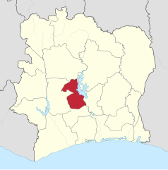
Marahoué – region Wybrzeża Kości Słoniowej, znajdujący się w centralnej części kraju. Jeden z dwóch regionów tworzących dystrykt Sassandra-Marahoué. Powierzchnia wynosi 9092 km²[1]. Populacja według spisu powszechnego z 2014 roku: 862 344 osoby[2]. Stolicą regionu jest Bouaflé.
Podział administracyjny
Region Marahoué jest podzielony na trzy departamenty[1]:
- Bouaflé
- Sinfra
- Zuénoula
Historia
Region został utworzony w 1997 roku, jako jednostka pierwszego rzędu[3]. W 2000 roku część jego obszaru (departament Oumé) wydzielono, by utworzyć nowy region Fromager[3]. W 2011 roku reforma administracyjna ustanowiła regiony jednostkami drugiego poziomu. Marahoué stał się częścią dystryktu Sassandra-Marahoué.
Przypisy
- ↑ a b ARDCI : Assemblée des Régions et Districts de Côte d'Ivoire – Découverte de la MARAHOUE, web.archive.org, 4 czerwca 2016 [dostęp 2020-06-21] [zarchiwizowane z adresu 2016-06-04].
- ↑ GeoHive – Cote d'Ivoire population statistics, web.archive.org, 22 listopada 2015 [dostęp 2020-06-21] [zarchiwizowane z adresu 2015-11-22].
- ↑ a b Cote d'Ivoire Districts, www.statoids.com [dostęp 2020-06-21].
Media użyte na tej stronie
Flag of the Ivory Coast, written by Jon Harald Søby, modified by Zscout370. The colors match to what is reported at http://fotw.vexillum.com/flags/ci.html.
Autor: Good Olfactory, Licencja: CC BY-SA 4.0
Locator map for Marahoué Region in Côte d'Ivoire when the 16 regions were created in 1997. Three new regions were created in 2000, including Fromager Region, which was carved out of Marahoué and Haut-Sassandra Regions.
Autor: Derivative work: User:Profoss - Original work:Uwe Dedering, Licencja: CC BY-SA 3.0
Location of region (see file name) in Côte d'Ivoire


