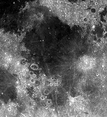
Mare Fecunditatis
| Ten artykuł od 2022-07 wymaga zweryfikowania podanych informacji. |
 | |
| Ciało niebieskie | |
|---|---|
| Średnica krateru | 990 km (pierścień zewnętrzny) |
| Głębokość krateru | 1,84 km |
| Źródło nazwy | "Morze Obfitości", "Morze Żyzności" |
Mare Fecunditatis, Mare Foecunditatis (łac. Morze Żyzności albo Morze Obfitości) to morze księżycowe znajdujące się po widocznej stronie Księżyca. Jego średnica to 909 km.
Na północnym zachodzie tego morza wylądowały radzieckie sondy kosmiczne Łuna 16 i Łuna 20.
Media użyte na tej stronie
Shiny LightSteelBlue button/marker widget. Used to mark the location of something such as a tourist attraction.
Autor:
- Nuvola_apps_kmoon.png: David Vignoni / derivative work: Lady Whistler (talk)
Icon from Nuvola icon theme for KDE 3.x.
cylindrical map projection of the Moon. The Moon's whole surface was mapped by the Clementine spacecraft in 1994, here North is at the top. The dark floor of crater Plato is at the middle top above Mare Imbrium, while the bright floor and rays of crater Tycho is near the middle bottom below Mare Imbrium. Mare Procellarum is at the near left, and Mare Tranquillitatis is just right of centre and Mare Crisium is at the near right. The far left and far right show the contrast of the mostly cratered farside with small isolated mare.
Photo of en:Mare Fecunditatis. You can make out Mare Tranquillitatis in the upper left corner of the picture below, while the patch of grey in the lower-left is Mare Nectaris. On the eastern edge of Fecunditatis is the crater Langrenus, seen as the lighter grey area on the right-center of the photo.
(c) Luc Viatour, CC-BY-SA-3.0
Nearly Full Moon view from earth In Belgium (Hamois).


