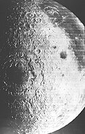
Mare Orientale
| ||
 | ||
| Ciało niebieskie | Księżyc | |
| Średnica krateru | 930 km | |
| Głębokość krateru | 6,04 km | |
| Wiek | < 3,85 Ga | |
| Źródło nazwy | "Morze Wschodnie" | |

Mare Orientale (łac. Morze Wschodnie) – morze księżycowe zlokalizowane na zachodnim skraju widocznej strony Księżyca. Ze względu na położenie obserwacja Mare Orientale z Ziemi jest dość utrudniona.
Nieznany jest wiek basenu, jaki wypełnia Mare Orientale, ponieważ żadna z misji Apollo nie pobrała z jego powierzchni próbek gruntu. Uważa się, że jest to jeden z najmłodszych basenów uderzeniowych na Księżycu, dużo młodszy od uformowanego około 3,85 mld lat temu Mare Imbrium.
Morze to ma średnicę 327 km i zajmuje centralną część krateru uderzeniowego o średnicy około 900 km. Krater ten i samo Mare Orientale powstały wskutek uderzenia w powierzchnię Księżyca dużej planetoidy. W przeciwieństwie do większości mórz księżycowych, Mare Orientale jest w raczej niewielkim stopniu pokryte skałami bazaltowymi (grubość ich warstwy dochodzi maksymalnie do 1 km) i ukazuje pierwotną strukturę krateru uderzeniowego.
Nazwa "Mare Orientale" po raz pierwszy pojawiła się w książce "Der Mond" niemieckiego astronoma Juliusa Franza w 1906 roku. Dopiero jednak badania Gererda Kuipera w latach 60. pozwoliły na ustalenie, że morze to jest pochodzenia kraterowego. Sam przymiotnik Orientale, czyli Wschodni, odnosi się do położenia morza na wschodnim skraju widocznej strony Księżyca; nazwa nie uległa zmianie mimo przemianowania strony wschodniej na zachodnią przez "konwencję astronautyczną" w roku 1961.
Media użyte na tej stronie
Shiny LightSteelBlue button/marker widget. Used to mark the location of something such as a tourist attraction.
Autor:
- Nuvola_apps_kmoon.png: David Vignoni / derivative work: Lady Whistler (talk)
Icon from Nuvola icon theme for KDE 3.x.
Mare Orientale or Orientale Basin. This image was taken by en:Lunar Orbiter 4.
en:Mare Orientale straddles both the near and far side. The basin has the most nearly complete concentric ring structure of any basin in the west. The surrounding basin material is of the Lower Imbrian epoch, with the mare material being of the Upper Imbrian epoch. The outermost conspicuous ring is Cordillera, bounded inwardly by steep scarp or gentle lip and topped by some ridgelike massifs. The mare-like material to the northeast is Lacus Autumni. You can also make out the crater Maunder among the northern region of the mare. Off to the southeast of Maunder is Kopff. Montes Rooks lines the eastern edge of the mare.
cylindrical map projection of the Moon. The Moon's whole surface was mapped by the Clementine spacecraft in 1994, here North is at the top. The dark floor of crater Plato is at the middle top above Mare Imbrium, while the bright floor and rays of crater Tycho is near the middle bottom below Mare Imbrium. Mare Procellarum is at the near left, and Mare Tranquillitatis is just right of centre and Mare Crisium is at the near right. The far left and far right show the contrast of the mostly cratered farside with small isolated mare.
(c) Luc Viatour, CC-BY-SA-3.0
Nearly Full Moon view from earth In Belgium (Hamois).


