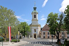
Maria Enzersdorf
| |||
 | |||
| |||
| Państwo | |||
|---|---|---|---|
| Kraj związkowy | |||
| Powiat | Mödling | ||
| Powierzchnia | 5,36 km² | ||
| Wysokość | 225 m n.p.m. | ||
| Populacja (1 stycznia 2014) • liczba ludności | 8 691 | ||
| • gęstość | 1 621 os./km² | ||
| Numer kierunkowy | 02236 | ||
| Kod pocztowy | 2344, 2346 | ||
| Tablice rejestracyjne | MD | ||
| Strona internetowa | |||
Maria Enzersdorf (do 1999 Maria Enzersdorf am Gebirge) – gmina targowa w Austrii, w kraju związkowym Dolna Austria, w powiecie Mödling. Liczy 8 691 mieszkańców (1 stycznia 2014)[1]. .
Zobacz też
- Enzersdorf
- Maria
Przypisy
Media użyte na tej stronie
Autor: Rosso Robot, Licencja: CC BY-SA 3.0
Location map of Lower Austria
Equirectangular projection. Geographic limits of the map:
- N: 49.02796° N
- S: 47.38301° N
- W: 14.44565° E
- E: 17.07430° E
Autor: Lencer, Licencja: CC BY-SA 3.0
Location map of Austria
Equirectangular projection, N/S stretching 150 %. Geographic limits of the map:
- N: 49.2° N
- S: 46.3° N
- W: 9.4° E
- E: 17.2° E
Autor: Bwag, Licencja: CC BY-SA 4.0
Westansicht der Franziskanerkloster-, Wallfahrts- und ehemalige Pfarrkirche hll. Maria Magdalena und Maria in der niederösterreichischen Marktgemeinde Maria Enzersdorf.
1454 erfolgte die Gründung des Klosters. Klostergebäude und Kirche waren 1472 vollendet, bei beiden Türkenbelagerungen (1529, 1683) jeweils zerstört. Von 1727 bis 1729 erfolgte Wiedererrichtung und Erweiterung. Eine weitere Erweiterung fand unter Richard Jordan von 1907 bis 1909 statt. Nachdem die Kirche 1784 eine Pfarrkirche wurde (bis 2014), ersetzte man 1788 den Dachreiter durch einen 38 m hohen Kirchturm.


