Marina del Rey
 | |
| Państwo | |
|---|---|
| Stan | |
| Hrabstwo | |
| Powierzchnia | 3,768 km² |
| Wysokość | 0 m n.p.m. |
| Populacja (2010) • liczba ludności • gęstość |
|
| Kod pocztowy | 90291–90292, 90295 |
Położenie na mapie metropolii Los Angeles  | |
Położenie na mapie Stanów Zjednoczonych  | |
Położenie na mapie Kalifornii  | |
| Portal | |
Marina del Rey – jednostka osadnicza w hrabstwie Los Angeles. W 2010 roku liczba mieszkańców miejscowości wyniosła 8866 osób.
Położenie
Marina del Rey wchodzi w skład obszaru metropolitalnego Los Angeles, jest niewielką (3,8 km²) „półenklawą” na terenie miasta. Od południowego wschodu graniczy z dzielnicą Venice, od północy z dzielnicą Playa del Rey.
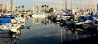
Miejscowość znana jest z dziewiętnastu portów jachtowych (marin) mogących pomieścić 5600 jachtów. Zarządzana jest przez władze hrabstwa.

Położenie Marina del Rey w hrabstwie Los Angeles
Przystań, od której Marina del Rey wzięła swoją nazwę

Panoramiczny widok na przystań (z pobliskiego budynku)
Linki zewnętrzne
Media użyte na tej stronie
Autor: Alexrk2, Licencja: CC BY 3.0
Ta mapa została stworzona za pomocą GeoTools.
Autor: Uwe Dedering, Licencja: CC BY-SA 3.0
Location map of the USA (without Hawaii and Alaska).
EquiDistantConicProjection:
Central parallel:
* N: 37.0° N
Central meridian:
* E: 96.0° W
Standard parallels:
* 1: 32.0° N
* 2: 42.0° N
Made with Natural Earth. Free vector and raster map data @ naturalearthdata.com.
Formulas for x and y:
x = 50.0 + 124.03149777329222 * ((1.9694462586094064-({{{2}}}* pi / 180))
      * sin(0.6010514667026994 * ({{{3}}} + 96) * pi / 180))
y = 50.0 + 1.6155950752393982 * 124.03149777329222 * 0.02613325650382181
      - 1.6155950752393982  * 124.03149777329222 *
     (1.3236744353715044  - (1.9694462586094064-({{{2}}}* pi / 180))
      * cos(0.6010514667026994 * ({{{3}}} + 96) * pi / 180))
Autor: NordNordWest, Licencja: CC BY 3.0
Location map of California, USA

The flag of Navassa Island is simply the United States flag. It does not have a "local" flag or "unofficial" flag; it is an uninhabited island. The version with a profile view was based on Flags of the World and as a fictional design has no status warranting a place on any Wiki. It was made up by a random person with no connection to the island, it has never flown on the island, and it has never received any sort of recognition or validation by any authority. The person quoted on that page has no authority to bestow a flag, "unofficial" or otherwise, on the island.

Flag of California. This version is designed to accurately depict the standard print of the bear as well as adhere to the official flag code regarding the size, position and proportion of the bear, the colors of the flag, and the position and size of the star.

Autor: Howcheng, Licencja: CC BY-SA 3.0
View of boats moored in Marina del Rey, California, USA, as viewed from the 11th floor of a nearby office building.

Autor: Alan Levine from Strawberry, United States, Licencja: CC BY 2.0
Walking the waterfront at Marina del Ray, CA

This map shows the unincorporated and incorporated areas in Los Angeles County, California.
- Marina del Rey— unincorporated — is highlighted in red.