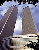
Marriott World Trade Center
 Marriott WTC na zdjęciu z Twin Towers | |
| Państwo | |
|---|---|
| Miejscowość | |
| Typ budynku | |
| Kondygnacje | 22 |
| Rozpoczęcie budowy | |
| Ukończenie budowy | |
| Zniszczono | |
Położenie na mapie stanu Nowy Jork (c) NordNordWest, CC BY 3.0 | |
Marriott World Trade Center (Three World Trade Center lub 3 World Trade Center) – nieistniejący budynek w nowojorskiej dzielnicy Lower Manhattan na Manhattanie. Rozpoczęcie budowy nastąpiło w 1979 roku, na potrzebę rozrastającej się spółki World Trade Center, zaś został ukończony w czerwcu 1981. Uroczyste otwarcie nastąpiło na początku lipca 1981[1].
Budynek został zniszczony 11 września 2001 poprzez spadające gruzy z płonących wież World Trade Center w trakcie ataków terrorystycznych[2].
Przypisy
- ↑ Eisner, Harvey: Terrorist Attack At New York World Trade Center (ang.). Firehouse Magazine, April 2002. [zarchiwizowane z tego adresu (2009-09-27)].
- ↑ Jim Dwyer: One Hotel's Fight to the Finish; At the Marriott, a Portal to Safety as the Towers Fell (ang.). 11 września, 2002.
Media użyte na tej stronie
Autor: Uwe Dedering, Licencja: CC BY-SA 3.0
Location map of the USA (without Hawaii and Alaska).
EquiDistantConicProjection:
Central parallel:
* N: 37.0° N
Central meridian:
* E: 96.0° W
Standard parallels:
* 1: 32.0° N
* 2: 42.0° N
Made with Natural Earth. Free vector and raster map data @ naturalearthdata.com.
Formulas for x and y:
x = 50.0 + 124.03149777329222 * ((1.9694462586094064-({{{2}}}* pi / 180))
      * sin(0.6010514667026994 * ({{{3}}} + 96) * pi / 180))
y = 50.0 + 1.6155950752393982 * 124.03149777329222 * 0.02613325650382181
      - 1.6155950752393982  * 124.03149777329222 *
     (1.3236744353715044  - (1.9694462586094064-({{{2}}}* pi / 180))
      * cos(0.6010514667026994 * ({{{3}}} + 96) * pi / 180))
(c) NordNordWest, CC BY 3.0
Location map of the State of New York, USA
The flag of Navassa Island is simply the United States flag. It does not have a "local" flag or "unofficial" flag; it is an uninhabited island. The version with a profile view was based on Flags of the World and as a fictional design has no status warranting a place on any Wiki. It was made up by a random person with no connection to the island, it has never flown on the island, and it has never received any sort of recognition or validation by any authority. The person quoted on that page has no authority to bestow a flag, "unofficial" or otherwise, on the island.
Autor: , Licencja: CC BY-SA 2.0
Autor: Alexrk2, Licencja: CC BY 3.0
Ta mapa została stworzona za pomocą GeoTools.
Autor: David Ohmer, Licencja: CC BY 2.0
Marriott World Trade Center and Twin Towers


