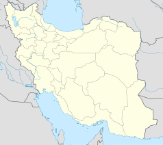
Masal
 | |
| Państwo | |
|---|---|
| Ostan | Gilan |
| Populacja (2016) • liczba ludności | 17 901 |
| 37°21′47″N 49°07′58″E/37,363056 49,132778 | |
Masal (pers. ماسال) – miasto w Iranie, w ostanie Gilan. W 2016 roku liczyło 17 901 mieszkańców.
Media użyte na tej stronie
Autor: Uwe Dedering, Licencja: CC BY-SA 3.0
Location map of Iran.
Equirectangular projection. Stretched by 118.0%. Geographic limits of the map:
* N: 40.0° N
* S: 24.5° N
* W: 43.5° E
* E: 64.0° E
Made with Natural Earth. Free vector and raster map data @ naturalearthdata.com.


