Massachusetts Bay Transportation Authority
| ||
 | ||
| Państwo | ||
| Siedziba | Boston | |

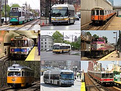
Massachusetts Bay Transportation Authority (MBTA, Agencja Transportu Zatoki Massachusetts) – organ wydzielony w roku 1964 z amerykańskiego stanu Massachusetts, którego funkcją jest finansowanie i zarządzanie systemem transportowym w aglomeracji Bostonu: autobusami, trolejbusami, tramwajami, lekkiej kolei, kolei podziemnej i podmiejską oraz promami. Zastąpiła wcześniejszą agencję, Metropolitan Transit Authority (MTA, Agencja Transportu Miejskiego).
MBTA określana jest przez pasażerów jako "The T", z powodu charakterystycznego loga (litera T w okręgu) zainspirowanego przez symbol sztokholmskiego metra.
W roku 2004 ze wszystkich środków transportu MBTA korzystało średnio ponad 790 tysięcy osób dziennie, w tym niemal 600 tysięcy podróżowało liniami kolejki podziemnej. Linia "zielona" metra w postaci lekkiej kolei miejskiej jest najbardziej obciążoną linią w Stanach Zjednoczonych.
Linki zewnętrzne
| ||||||||||||||||||||||||||||||||||||||||||||||||||||||||||||||||||||||||||||||||||||||||||||||||||||||||||||||||||||||||||||||||||||||||||||||||||||||
| ||||||||||||||||||||||
Media użyte na tej stronie
The flag of Navassa Island is simply the United States flag. It does not have a "local" flag or "unofficial" flag; it is an uninhabited island. The version with a profile view was based on Flags of the World and as a fictional design has no status warranting a place on any Wiki. It was made up by a random person with no connection to the island, it has never flown on the island, and it has never received any sort of recognition or validation by any authority. The person quoted on that page has no authority to bestow a flag, "unofficial" or otherwise, on the island.
Autor: ArnoldReinhold, Licencja: CC-BY-SA-3.0
New (2004) Massachusetts Bay Transportation Authority Neoplan trolleybus number 4120, operating near Harvard Square in Cambridge, Massachusetts. Note unique left-side door to allow passenger loading in Harvard Square tunnel.
Autor: Original photos taken by Adam E. Moreira. Replacement images by various authors; see list under source, Licencja: CC-BY-SA-3.0
Examples of all MBTA services except for MBTA Boat. This has been designed primarily for the infobox at the top of the Massachusetts Bay Transportation Authority page on Wikipedia, a topic of public interest.
-
Top row:
- Left: Green Line Breda Type 8 LRV #3840 is stopped for a red light at Commonwealth Avenue and Carlton Street on the B.
- Center: New Flyer XDE40 bus #1799 on route 1 at MIT.
- Right: Orange Line Hawker Siddeley #12 Main Line train led by #01240 enters Ruggles Station.
-
Center row
- Left: The first Blue Line #5 East Boston train in revenue service at Government Center
- Center: Neoplan AN440LF trackless trolley #4111 exits the Harvard Tunnel on the 71.
- Right: EMD GP40MC #1136 pulls Train 465 into Porter Station.
-
Bottom row
- Left: St. Louis Car PCC car #3087 on the Ashmont-Mattapan Line.
- Center: New Flyer XDE60 #1289 on SL5 route on Washington Street.
- Right: #3 Red Line train leaves Charles/MGH over the Longfellow Bridge.


