Mayo (hrabstwo)
| |||||
| |||||
| |||||
| Państwo | |||||
|---|---|---|---|---|---|
| Prowincja | Connacht | ||||
| Siedziba | Castlebar | ||||
| Powierzchnia | 5397 km² | ||||
| Populacja (2011) • liczba ludności | 130 638[1] | ||||
| • gęstość | 24,21 os./km² | ||||
| Tablice rejestracyjne | MO | ||||
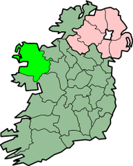
Położenie na mapie Irlandii | |||||
| Strona internetowa | |||||
Mayo (irl. Contae Mhaigh Eo) – hrabstwo na zachodnim wybrzeżu Irlandii, w prowincji Connacht. Jego stolicą jest Castlebar, największe miasto hrabstwa.
Geografia
W pobliżu granicy z hrabstwem Roscommon znajduje się świątynia Knock. W Mayo mieści się również Croagh Patrick, góra, na której święty Patryk modlił się i pościł przez czterdzieści dni i nocy. Najwyższym punktem w hrabstwie (a zarazem w prowincji Connacht) jest Mweelrea (814 metrów). Rzeka Moy na północnym wschodzie jest znana z połowów łososi. W obszarze Mayo leży również największa wyspa Irlandii – Achill. Południowa część hrabstwa wchodzi w skład regionu Connemara.
Sport
Mayo jest też znane z powodu swojej drużyny grającej w Gaelic Football, oraz jej niezdolności do wygrania ogólnoirlandzkich finałów w ostatnich latach. Ostatnio wygrali oni Sam Maguire Cup w roku 1951. Michael Davitt, założyciel Irish Land League, urodził się w Mayo. Most w Achill wziął od niego nazwę.
Miasta i wioski hrabstwa Mayo
- Aughagower, Aughleam (An Eachléim)
- Balla, Ballina, Ballindine, Ballinrobe, Ballintubber, Ballycastle, Ballyhaunis, Bangor Erris, Bekan, Bellavary, Belderrig (Béal Deirg), Belmullet (Béal an Mhuirthéad)
- Carrowteige (Ceathrú Thaidhg), Castlebar, Castlehill, Charlestown, Claremorris, Cong, Cregganbaun, Cross, Crossmolina
- Foxford
- Gob an Choire (Achill Sound)
- Hollymount
- Keel, Kilkelly, Killala, Kilmaine, Kiltimagh, Knock
- Lecanvey, Louisburgh
- Mayo, Mulrany, Murrisk
- Neale, Newport
- Partry, Pontoon
- Ross Port (Ros Dumhach)
- Shrule, Strade, Swinford (Irlandia)
- Toormakeady (Tuar Mhic Éadaigh)
- Westport
Inne ciekawe miejsca
- Zamek Ashford
- Wyspa Achill
- Ballintubber Abbey
- Wyspa Clare
- Croagh Patrick
- Knock International Airport
- Lough Mask
- Mullet półwysep
- Góry Nephin Beg
- Góry Partry
- Zamek Rockfleet
Przypisy
- ↑ Census 2011 Population Classified by Area (ang.). [dostęp 2012-10-20].
Media użyte na tej stronie
Autor: CeltBrowne, Licencja: CC BY-SA 4.0
Digital recreation of The Coat of Arms ("crest") of County Mayo in the Republic of Ireland, based on the following official description: "Per fess gules and argent in chief four crosses one and three the first patriarchal the others passion crosses or, in base on waves of the sea a lymphad proper, the whole within a bordure of the third charged with nine yew trees also proper, with the Crest: On a mount vert a garden rose slipped or and with the Motto: Dia is Muire linn."
Autor: Johannes Rössel (talk), Licencja: CC-BY-SA-3.0
GAA county colours of Mayo: Green and Red
Autor: User Morwen on en.wikipedia, Licencja: CC-BY-SA-3.0
map of County Mayo, Ireland
- 08:06, 5 February 2004 Morwen 200x249 (30486 bytes) (map)


