Mejit
| ||
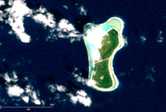
 Wyspa Mejit na zdjęciu NASA | ||
| Państwo | ||
| Akwen | Ocean Spokojny | |
| Powierzchnia | 1,86[1] km² | |
| Populacja (2011) • liczba ludności • gęstość | 348[2][3] 483[3] os./km² | |
Mejit (ang. Mejit Island, marszal. Mājej)[4][a] – niewielka wysepka w łańcuchu wysp Ratak Chain Wysp Marshalla na Oceanie Spokojnym.
Wyspa została odkryta przez hiszpańskiego konkwistadora Miguela Lópeza de Legazpi (1502–1572) w 1565 roku[5].
W latach 1964–1967 na wyspie stwierdzono występowanie 17 gatunków roślin i 5 gatunków ptaków, m.in. występował tu albatros ciemnolicy – notowany jedynie na tej wyspie spośród wszystkich Wysp Marshalla[6].
Na wyspie znajduje się port lotniczy Mejit (kod IATA: NMU)[7].
Uwagi
- ↑ W przeszłości atol nazywano Medschid, Mesid, Metidj, Miadi, Neujahrsinsel, New Year's I.. Patrz Digital Micronesia-An Electronic Library & Archive.
Przypisy
- ↑ Digital Micronesia-An Electronic Library & Archive is: Marshall Islands Atoll Information Mejit Island (ang.). [dostęp 2016-07-31].
- ↑ Marshall Islands Guide: Mejit Island (ang.). [dostęp 2016-08-01].
- ↑ a b Economic Policy, Planning, and Statistics Office, Office of the President: The RMI 2011 Census of Population and Housing. Summary and Highlights Only (ang.). U.S. Department of the Interior, 2016-08-01. [dostęp 2016-07-26].
- ↑ Nazewnictwo Geograficzne Świata. Zeszyt 1. Komisja Standaryzacji Nazw Geograficznych, 2004, s. 143. ISBN 83-239-7552-3. (pol.)
- ↑ Max Quanchi, John Robson: Historical Dictionary of the Discovery and Exploration of the Pacific Islands. Lanham, Maryland; Toronto; Oxford: The Scarecrow Press, Inc., 2016-08-01, s. XX. ISBN 0-8108-5395-7. (ang.)
- ↑ A. Binion Amerson Jr.: Atoll Research Bulletin No. 127: Ornitology of the Marshall and Gilbert Islands. Waszyngton, U.S.A.: The Smithsonian Institute, 1969, s. 55.
- ↑ MJB - Mejit, MH - Airport - Great Circle Mapper (ang.). Great Circle Mapper. [dostęp 2016-08-01].
Media użyte na tej stronie
Autor: Uwe Dedering, Licencja: CC BY-SA 3.0
Relief location map of Oceania.
- Projection: Lambert azimuthal equal-area projection.
- Area of interest:
- N: 35.0° N
- S: -55.0° N
- W: 110.0° E
- E: 230.0° E (This is -130° E)
- Projection center:
- NS: -10.0° N
- WE: 170.0° E
- GMT projection: -JA170/-5/20c
- GMT region: -R79.58168799459713/-44.42200097096855/-120.83787447194456/33.90289238708686r
- GMT region for grdcut: -R80.0/-63.0/260.0/39.0r
- Relief: SRTM30plus.
- Made with Natural Earth. Free vector and raster map data @ naturalearthdata.com.
Autor: NordNordWest, Licencja: CC BY 3.0
Location map of the Marshall Islands
natural color satellite image of Mejit Island, Ratak Chain, Marshall Islands, Micronesia, Pacific Ocean


