Melton (borough)
| dystrykt niemetropolitalny | |
(c) Mat Fascione, CC BY-SA 2.0 Tablica drogowa przy wjeździe na teren dystryktu | |
| Państwo | |
|---|---|
| Kraj | |
| Region | East Midlands |
| Hrabstwo | Leicestershire |
| Siedziba | Melton Mowbray |
| Powierzchnia | 481 km² |
| Populacja (2016) • liczba ludności | 50 878[1] |
| • gęstość | 106 os./km² |
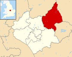
| Położenie na mapie Leicestershire Contains Ordnance Survey data © Crown copyright and database right, CC BY-SA 3.0 | |
| Strona internetowa | |
| Portal | |
Melton – dystrykt w hrabstwie Leicestershire w Anglii. Od kilkunastu lat utrzymuje stosunki partnerskie z miastem Sochaczew woj. mazowieckie.
Miasta
Inne miejscowości
Ab Kettleby, Asfordby, Asfordby Hill, Ashby Folville, Belvoir, Bottesford, Brooksby, Broughton and Old Dalby, Buckminster, Burrough on the Hill, Burton Lazars, Burton and Dalby, Chadwell, Coston, Croxton Kerrial, Eastwell, Eaton, Freeby, Frisby on the Wreake, Gaddesby, Garthorpe, Goadby Marwood, Great Dalby, Harby, Harston, Hose, Kirby Bellars, Knipton, Little Dalby, Long Clawson, Muston, Old Dalby, Pickwell, Redmile, Saltby, Saxelbye, Scalford, Sewstern, Somerby, Sproxton, Stapleford, Stathern, Stonesby, Thorpe Arnold, Waltham on the Wolds, Wycomb, Wymondham.
Przypisy
- ↑ Population Estimates for UK, England and Wales, Scotland and Northern Ireland - Office for National Statistics, www.ons.gov.uk [dostęp 2017-10-22] (ang.).
Media użyte na tej stronie
Flag of England. Saint George's cross (a red cross on a white background), used as the Flag of England, the Italian city of Genoa and various other places.
Contains Ordnance Survey data © Crown copyright and database right, CC BY-SA 3.0
Map of Leicestershire, UK with Melton highlighted.
Equirectangular map projection on WGS 84 datum, with N/S stretched 160%(c) Mat Fascione, CC BY-SA 2.0
Entering the Borough of Melton along the A607 Melton Road.


