Melton Mowbray
(c) David Lally, CC BY-SA 2.0 | |
| Państwo | |
|---|---|
| Kraj | |
| Hrabstwo | |
| Dystrykt | |
| Populacja (2001) • liczba ludności |
|
| Nr kierunkowy | 01664 |
| Kod pocztowy | LE13 |
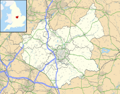
Położenie na mapie Leicestershire Contains Ordnance Survey data © Crown copyright and database right, CC BY-SA 3.0 | |
Położenie na mapie Wielkiej Brytanii (c) Karte: NordNordWest, Lizenz: Creative Commons by-sa-3.0 de | |
| Portal | |
Melton Mowbray (lub Melton) – miasto w Anglii, w północno-wschodniej części hrabstwa Leicestershire, w dystrykcie Melton. Miasto jest położone 25 kilometrów na północny wschód od Leicesteru i 160 kilometrów na północ od Londynu. Miasto jest położone nad rzeką Wreake i ma połączenie kolejowe z Leicesterem. W 2001 roku liczyło 25 554 mieszkańców[1].
Etymologia nazwy
Nazwa miasta Melton wywodzi się z wczesnoangielskiego słowa Medeltone – co znaczy „miasto średniej wielkości otoczone wioskami”. Mowbray natomiast to normańskie nazwisko właściciela średniowiecznego miasta – Roberta de Mowbray. Melton Mowbray jest wspomniane w Domesday Book (1086) jako Medeltone[2].
Warto zobaczyć
- Kościół św. Marii – największy kościół parafialny w hrabstwie Leicestershire z pozostałościami z XIII-XV wieku. Wysoka wieża dominuje nad miastem, a niektóre jej kamienne elementy datowane są na 1170 rok.
- Melton Carnegie Museum – muzeum zajmuje się lokalną historią.
Melton Mowbray znane jest z pasztetów wieprzowych oraz sera stilton produkowanego z krowiego mleka.
Ludzie związani z Melton
- Graham Chapman – aktor znany z cyklu „Latający cyrk Monty Pythona”.
- Paul Anderson – piłkarz Liverpool.
- Terri Dwyer – prezenter telewizyjny.
- Craig Dolby – kierowca wyścigowy.
- Alfie Jackson – wokalista i gitarzysta grupy The Holloways.
Miasta partnerskie
Najnowsza historia
W 1964 w mieście zainwestowało towarzystwo Production Engineering Research Association of Great Britain (PERA) i zatrudniło ok. 400 pracowników. Petfoods jest obecne w Melton od 1951 jako Chappie Ltd, zatrudniało wtedy ponad 2000 osób, w tej chwili ma ok. 1000 pracowników. Nazwę Masterfoods przyjęło w styczniu 2002. Masterfoods ma w tej chwili swą główną siedzibę blisko Melton w Waltham-on-the-Wolds.
Przypisy
- ↑ KS01 Usual resident population: Census 2001, Key Statistics for urban areas. Office for National Statistics. [dostęp 2016-11-23]. [zarchiwizowane z tego adresu (2004-07-23)]. (ang.).
- ↑ Leicestershire H-R. The Domesday Book online. [dostęp 2016-11-23]. (ang.).
Linki zewnętrzne
- Strona oficjalna. melton.gov.uk. [zarchiwizowane z tego adresu (2008-06-28)]..
Media użyte na tej stronie
(c) Karte: NordNordWest, Lizenz: Creative Commons by-sa-3.0 de
Location map of the United Kingdom
Flag of England. Saint George's cross (a red cross on a white background), used as the Flag of England, the Italian city of Genoa and various other places.
The flag of Navassa Island is simply the United States flag. It does not have a "local" flag or "unofficial" flag; it is an uninhabited island. The version with a profile view was based on Flags of the World and as a fictional design has no status warranting a place on any Wiki. It was made up by a random person with no connection to the island, it has never flown on the island, and it has never received any sort of recognition or validation by any authority. The person quoted on that page has no authority to bestow a flag, "unofficial" or otherwise, on the island.
Contains Ordnance Survey data © Crown copyright and database right, CC BY-SA 3.0
Map of Leicestershire, UK with the following information shown:
- Administrative borders
- Coastline, lakes and rivers
- Roads and railways
- Urban areas
Equirectangular map projection on WGS 84 datum, with N/S stretched 160%
Geographic limits:
- West: 1.80W
- East: 0.50W
- North: 53.00N
- South: 52.36N


