Memorial Park
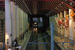
Tramwaj wjeżdżający na stację Memorial Park od strony Pasadeny | |
| Państwo | |
|---|---|
| Data otwarcia | 26 lipca 2003 |
| Złota linia metra | |
| Poprzednia stacja | Del Mar |
| Następna stacja | Lake |
| Portal | |
Memorial Park to stacja złotej linii metra w Los Angeles znajdująca się przy skrzyżowaniu East Holly Street i Arroyo Parkway w północnej części Starego Miasta w Pasadenie (Old Town Pasadena)[1]. Stacja znajduje się pod apartamentowcem Holly Street Village Apartment zbudowanym w roku 1994. Instalacja artystyczna na stacji nosi nazwę Pierwsi artyści w południowej Kalifornii: historia (The First Artists in Southern California: A Short Story) jej autorem jest John Valadez.
Godziny kursowania
Tramwaje złotej linii kursują między 5.00 a 0.15 w nocy[2].
Miejsca użyteczności publicznej
W pobliżu znajdują się:
- Armory Center for the Arts
- Art Center College of Design
- Fuller Theological Seminary
- Memorial Park & Levitt Pavilion
- Norton Simon Museum
- Old Pasadena Shopping and Dining District
- Pacific Asia Museum
- Pasadena Civic Center
- Pasadena Museum of California Art
- Paseo Colorado Shopping Center
- Rose Bowl
Połączenia autobusowe
- Metro Local: 180, 181, 256, 260, 267, 686
- Metro Rapid: 762, 780
- Transit Foothill: 187, 690
- Commuter LADOT Express: 549
- Pasadena ARTS:10, 20, 40, 51, 52
Wjazd na stację tramwaju jadącego w kierunku Los Angeles
Przypisy
- ↑ Gold Line - Memorial Park Connections Map. [dostęp 2011-03-01]. [zarchiwizowane z tego adresu (2012-04-12)].
- ↑ Line 804 - Metro Gold Line - Sierra Madre Villa - Union Station - Atlantic. [dostęp 2013-06-25]. [zarchiwizowane z tego adresu (2013-06-25)].
Linki zewnętrzne
Media użyte na tej stronie
Autor: Uwe Dedering, Licencja: CC BY-SA 3.0
Location map of the USA (without Hawaii and Alaska).
EquiDistantConicProjection:
Central parallel:
* N: 37.0° N
Central meridian:
* E: 96.0° W
Standard parallels:
* 1: 32.0° N
* 2: 42.0° N
Made with Natural Earth. Free vector and raster map data @ naturalearthdata.com.
Formulas for x and y:
x = 50.0 + 124.03149777329222 * ((1.9694462586094064-({{{2}}}* pi / 180))
      * sin(0.6010514667026994 * ({{{3}}} + 96) * pi / 180))
y = 50.0 + 1.6155950752393982 * 124.03149777329222 * 0.02613325650382181
      - 1.6155950752393982  * 124.03149777329222 *
     (1.3236744353715044  - (1.9694462586094064-({{{2}}}* pi / 180))
      * cos(0.6010514667026994 * ({{{3}}} + 96) * pi / 180))
Autor: NordNordWest, Licencja: CC BY 3.0
Location map of California, USA
The flag of Navassa Island is simply the United States flag. It does not have a "local" flag or "unofficial" flag; it is an uninhabited island. The version with a profile view was based on Flags of the World and as a fictional design has no status warranting a place on any Wiki. It was made up by a random person with no connection to the island, it has never flown on the island, and it has never received any sort of recognition or validation by any authority. The person quoted on that page has no authority to bestow a flag, "unofficial" or otherwise, on the island.
(c) Labanex z angielskiej Wikipedii, CC BY 2.5
Salaam Allah took this picture. Camera facing north. Here you can see the Holly Street Apartments directly above the station. On the left is Memorial Park.
Autor: Alexrk2, Licencja: CC BY 3.0
Ta mapa została stworzona za pomocą GeoTools.
Red Line circle.
Autor: Salaam Allah (http://en.wikipedia.org/wiki/User:Labanex), Licencja: CC BY 2.5
Metro Gold Line trains at Memorial Park Station in Pasadena, California from English Wikipedia.
Silver Line square (for Los Angeles Metro).
(c) DaveofCali z angielskojęzycznej Wikipedii, CC-BY-SA-3.0
Passengers at the Memorial Park Station in Pasadena await as a Gold Line train approaches the platform
Purple Line circle.
A specific Metro line identifier.


