Menlo Park (Kalifornia)
| ||||
 | ||||
| Państwo | ||||
|---|---|---|---|---|
| Stan | ||||
| Hrabstwo | ||||
| Prawa miejskie | 1874 | |||
| Kod statystyczny | ||||
| Zarządzający | Rich Cline | |||
| Powierzchnia | 45,105 km² | |||
| Wysokość | 22 m n.p.m. | |||
| Populacja (2010) • liczba ludności • gęstość |
| |||
| Nr kierunkowy | 650 | |||
| Kod pocztowy | 94025-94029 | |||
| Strefa czasowa | ||||
| Strona internetowa | ||||
| Portal | ||||
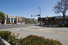
Menlo Park – miasto w hrabstwie San Mateo w stanie Kalifornia w Stanach Zjednoczonych. Liczba mieszkańców, zgodnie ze spisem z 2010 roku to 32026 osób[1], a szacunki z 2019 roku mówią o 34698 osobach[2]. Miasto ma powierzchnię 45,1 km², z czego 26,2 km² to powierzchnia lądowa, a pozostałe 18,9 km² to powierzchnia wodna (rzeki, jeziora).
W mieście znalazły swą siedzibę przedsiębiorstwa, popularnie zwane firmami z Doliny Krzemowej (Silicon Valley). W mieście ma swoją nową siedzibę Meta Platforms, znajduje się w nim też siedziba SRI International, poprzednio Stanford Research Institute, Seminarium i Uniwersytet Archidiecezji św. Patryka.
Przypisy
- ↑ a b Menlo Park (city), California (ang.). quickfacts.census.gov. [dostęp 2021-04-10]. [zarchiwizowane z tego adresu (2012-09-01)].
- ↑ Population and Housing Unit Estimates Tables (ang.). census.gov. [dostęp 2021-04-10].
Linki zewnętrzne
- Oficjalna strona miasta (ang.)
Media użyte na tej stronie
Autor: NordNordWest, Licencja: CC BY 3.0
Location map of California, USA
Autor: Uwe Dedering, Licencja: CC BY-SA 3.0
Location map of the USA (without Hawaii and Alaska).
EquiDistantConicProjection:
Central parallel:
* N: 37.0° N
Central meridian:
* E: 96.0° W
Standard parallels:
* 1: 32.0° N
* 2: 42.0° N
Made with Natural Earth. Free vector and raster map data @ naturalearthdata.com.
Formulas for x and y:
x = 50.0 + 124.03149777329222 * ((1.9694462586094064-({{{2}}}* pi / 180))
      * sin(0.6010514667026994 * ({{{3}}} + 96) * pi / 180))
y = 50.0 + 1.6155950752393982 * 124.03149777329222 * 0.02613325650382181
      - 1.6155950752393982  * 124.03149777329222 *
     (1.3236744353715044  - (1.9694462586094064-({{{2}}}* pi / 180))
      * cos(0.6010514667026994 * ({{{3}}} + 96) * pi / 180))
The flag of Navassa Island is simply the United States flag. It does not have a "local" flag or "unofficial" flag; it is an uninhabited island. The version with a profile view was based on Flags of the World and as a fictional design has no status warranting a place on any Wiki. It was made up by a random person with no connection to the island, it has never flown on the island, and it has never received any sort of recognition or validation by any authority. The person quoted on that page has no authority to bestow a flag, "unofficial" or otherwise, on the island.
Flag of California. This version is designed to accurately depict the standard print of the bear as well as adhere to the official flag code regarding the size, position and proportion of the bear, the colors of the flag, and the position and size of the star.
Logo of Menlo Park, California


