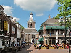
Meppel
 | |||||
| Państwo | |||||
|---|---|---|---|---|---|
| Prowincja | |||||
| Burmistrz | Jan Westmaas (2014)[1] | ||||
| Powierzchnia | 56,98 km² | ||||
| Populacja (2006) • liczba ludności • gęstość | 30 544 546,7 os./km² | ||||
| Nr kierunkowy | 0522 | ||||
| Kod pocztowy | 7940-7949 | ||||
 | |||||
| Strona internetowa | |||||
Meppel – miasto w Holandii, w prowincji Drenthe, nad Meppelerdiep, przy granicy z Overijssel i autostradzie A32.
Informacje podstawowe
- Populacja: 30 638 mieszkańców
- Gęstość zaludnienia: 546 osób/km²
- Powierzchnia: 56,98 km²
Przypisy
- ↑ meppel.nl: Jan Westmaas (niderl.). [dostęp 2014-07-11]. [zarchiwizowane z tego adresu (2014-07-15)].
Media użyte na tej stronie
Flag of Meppel, in Drenthe province, the Netherlands.
Location map of Dutch municipality in Drenthe. All images of this type by Mtcv have been released in the Public Domain by him
Coat of arms of the Dutch municipality of Meppel.
Autor: Erik Frohne, Licencja: CC BY-SA 3.0
Location map of province Drenthe in the Netherlands
Equirectangular projection, N/S stretching 166 %. Geographic limits of the map:
- N: 53.30° N
- S: 52.60° N
- W: 6.10° E
- E: 7.10° E
Autor: Michielverbeek, Licencja: CC BY-SA 3.0
To jest zdjęcie holenderskiego zabytku (rijksmonument) numer 28632


