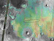
Meridiani Planum

Meridiani Planum – równina na Marsie położona 2 stopnie na południe od równika w najbardziej wysuniętej na zachód części Terra Meridiani. Równina ta ma rozmiary na 127 na 63 km zajmując obszar blisko 8000 kilometrów kwadratowych[1]. Występują na niej kryształy hematytu, minerału, który na Ziemi powstaje w pobliżu źródeł termalnych lub na dnie stojących zbiorników wodnych. Wielu naukowców uważa, że w rejonie Meridiani Planum istniały kiedyś źródła termalne lub zbiorniki wodne. Kryształy hematytu stanowią część warstwowej formacji skał osadowych o grubości od 200 do 800 metrów. Inne występujące na równinie formacje geologiczne to bazalt wulkaniczny i kratery uderzeniowe.
Łazik marsjański Opportunity
W roku 2004 na Meridiani Planum wylądował Opportunity jeden z dwu łazików wysłanych przez NASA w ramach misji Mars Exploration Rover. Równina miała być też miejscem lądowania Mars Surveyor 2001 Lander, który jednak został odwołany po porażce misji Mars Climate Orbiter i Mars Polar Lander.
Wyniki badań Opportunity wskazują, że miejsce lądowania sondy było kiedyś nasiąknięte ciekłą wodą, prawdopodobnie o znacznym zasoleniu i kwasowości. Wskazuje na to obecność warstwowanych przekątnie osadów, drobnych, sferoidalnych kamyczków będących konkrecjami, szczelin w skałach, a także znacznych ilości siarczanu magnezu i innych minerałów zawierających siarczany, takich jak jarosyt.
Kratery na Meridiani Planum[2]
- Airy - średnica 40 km, położony ok. 375 km na południowy zachód od łazika Opportunity
- Argo - odwiedzony przez Opportunity
- Beagle - odwiedzony przez Opportunity
- Beer
- Eagle - miejsce lądowania Opportunity, ok. 30 m średnicy
- Emma Dean - odwiedzony przez Opportunity
- Endeavour - ostatni cel badań Opportunity, 22 kilometry średnicy
- Endurance - odwiedzony przez Opportunity
- Erebus - odwiedzony przez Opportunity
- Mädler
- Santa Maria - odwiedzony przez Opportunity, średnica ok. 90 m
- Victoria - odwiedzony przez Opportunity, średnica ok. 750 m
- Vostok - odwiedzony przez Opportunity
Linki zewnętrzne
- Mapa w serwisie Google Maps
- Artykuł The sedimentary rocks of Sinus Meridiani: Five key observations from data acquired by the Mars Global Surveyor and Mars Odyssey orbiters
Przypisy
- ↑ Zdjęcie pyłów wulkanicznych na Marsie
- ↑ Są to nazwy nieoficjalne
Media użyte na tej stronie
Meridiani Planum hematite deposits
This image shows the abundance and location of the mineral grey hematite at the Mars Exploration Rover Opportunity's landing site, Meridiani Planum, Mars. Opportunity is targeted to land somewhere inside the oval, approximately 71 kilometers (45 miles) long, on January 24, 2004 Pacific Standard Time. The background surface image of Meridiani Planum is a mosaic of daytime infrared images acquired by the thermal emission imaging system instrument on NASA's Mars Odyssey Orbiter. Superimposed on this image mosaic is a rainbow-colored map showing the abundance and location of grey hematite, as mapped by the thermal emission spectrometer on NASA's Mars Global Surveyor orbiter. Red and yellow indicates higher concentrations, whereas green and blue areas denote lower levels. On Earth, grey hematite is an iron oxide mineral that typically forms in the presence of liquid water. The rover Opportunity will study the martian terrain to determine whether liquid water was present in the past when rocks were being formed, and ultimately will address whether that past environment was favorable for life.NASA's Mars Exploration Rover Opportunity recently stopped to analyze an exposure of rock near "Beagle Crater," on a target nicknamed "Baltra." Nearly 100 sols, or Martian days, had passed since Opportunity had last analyzed one of the now-familiar rock exposures seen on the Plains of Meridiani. The rover ground a 3-millimeter-deep (0.12-inch-deep) hole in the rock using the rock abrasion tool on sol 893 (July 29, 2006) while stationed about 25 meters (82 feet) from the southwest rim of Beagle Crater.
Scientists wanted to analyze the outcrop one more time before driving the rover onto the ring of smooth material surrounding "Victoria Crater." Opportunity's analysis showed the rock to be very similar in its elemental composition to other exposures encountered during the rover's southward trek across Meridiani Planum.
Opportunity's microscopic imager acquired this view on sol 894 (July 30, 2006) while the target was fully shadowed. The view shows an area about 6 centimeters (2.4 inches) across, just spanning the diameter of the hole ground into Baltra. The image resolution of 30 microns per pixel makes it possible to see features as small as 0.1 millimeter (0.004 inch).
Image Credit: NASA/JPL-Caltech/Cornell/USGS


