Merrick
| Ten artykuł od 2022-07 wymaga zweryfikowania podanych informacji. |
 | |
| Państwo | |
|---|---|
| Kraj | |
| Położenie | |
| Pasmo | |
| Wysokość | 843 m n.p.m. |
| Wybitność | 705 m |
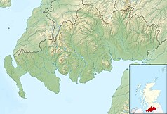
Położenie na mapie Dumfries and Galloway Contains Ordnance Survey data © Crown copyright and database right, CC BY-SA 3.0 | |
Położenie na mapie Szkocji | |
Merrick (gael. Mearaig) – najwyższe wzniesienie Wyżyny Południowoszkockiej o wysokości 843 m n.p.m.
Media użyte na tej stronie
Autor: Alexrk2, Licencja: CC BY-SA 3.0
Location map of the United Kingdom
Black up-pointing triangle ▲, U+25B2 from Unicode-Block Geometric Shapes (25A0–25FF)
Contains Ordnance Survey data © Crown copyright and database right, CC BY-SA 3.0
Relief map of Dumfries and Galloway, UK.
Equirectangular map projection on WGS 84 datum, with N/S stretched 170%
Geographic limits:
- West: 5.25W
- East: 2.75W
- North: 55.50N
- South: 54.50N
Autor: Oryginalnym przesyłającym był Grinner z angielskiej Wikipedii, Licencja: CC-BY-SA-3.0
A picture of Merrick in Galloway (Scotland), seen from the Rig of Loch Enoch. Taken on 22nd May 2005, by User:Grinner
(c) Eric Gaba, NordNordWest, Uwe Dedering, CC BY-SA 3.0
Location map of Scotland, United Kingdom


