Met Office
| Ten artykuł od 2022-02 zawiera treści, przy których brakuje odnośników do źródeł. |
| Państwo | |
|---|---|
| Data utworzenia | 1854 |
Położenie na mapie Exeteru Contains Ordnance Survey data © Crown copyright and database right, CC BY-SA 3.0 | |
Położenie na mapie Wielkiej Brytanii (c) Karte: NordNordWest, Lizenz: Creative Commons by-sa-3.0 de | |
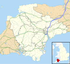
Położenie na mapie Devonu Contains Ordnance Survey data © Crown copyright and database right, CC BY-SA 3.0 | |
Met Office (dawniej Meteorogical Office) – narodowy serwis meteorologiczny Wielkiej Brytanii. Met Office jest związany z ministerstwem obrony.
Interdyscyplinarne Centrum Modelowania Matematycznego w Uniwersytecie Warszawskim wykorzystuje numeryczny model pogody z Met Office. Biura Met Office znajdują się w Exeterze, w hrabstwie Devon.
Media użyte na tej stronie
(c) Karte: NordNordWest, Lizenz: Creative Commons by-sa-3.0 de
Location map of the United Kingdom
Contains Ordnance Survey data © Crown copyright and database right, CC BY-SA 3.0
Map of Devon, UK with the following information shown:
- Administrative borders
- Coastline, lakes and rivers
- Motorways and primary routes
- Urban areas
Equirectangular map projection on WGS 84 datum, with N/S stretched 150%
Geographic limits:
- West: 4.72W
- East: 2.86W
- North: 51.3N
- South: 50.16N
(c) William M. Connolley z angielskojęzycznej Wikipedii, CC-BY-SA-3.0
Panorama of the new UKMO building in Exeter, taken 2005/02/08 by William M. Connolley with a nikon coolpix 950. 5 individual shots have been glued together. Note: the building is technically MOD property and as such photography is not officially permitted. I was approached, politely, by security after taking the pictures and invited to explain myself; eventually a higher-level official decided that my pics of the outside were OK.
Contains Ordnance Survey data © Crown copyright and database right, CC BY-SA 3.0
Map of Exeter, Devon, UK with electoral wards as of 2016 shown.
Equirectangular map projection on WGS 84 datum, with N/S stretched 150%
Geographic limits:
- West: 3.58W
- East: 3.45W
- North: 50.77N
- South: 50.66N


