Metra
| kolej aglomeracyjna | |
 | |
 | |
| Państwo | |
|---|---|
| Lokalizacja | Obszar metropolitalny Chicago |
| Operator | Regional Transportation Authority |
| Liczba linii | 11[1] |
| Lata funkcjonowania | od 1984 |
| Dzienna liczba pasażerów | 322,100 (dni powszednie) |
| Infrastruktura | |
| Długość sieci | 487.7 mil |
| Liczba stacji | 239[1] |
| Portal | |
Metra (oficjalnie Northeast Illinois Regional Commuter Railroad Corporation) jest operatorem kolei podmiejskiej działającym na terenie Chicago (Illinois, USA) i otaczających przedmieści. System obsługuje około 200 stacji i 11 linii, obejmując swoim zasięgiem 6 hrabstw (Cook, DuPage, Kane, Lake, McHenry i Will Counties). Operator obsługuje ponad 80 milionów przejazdów rocznie.
Linie i stacje
| Linia | Stacja w Chicago | Stacja końcowa | Długość linii | Liczba stacji | Data utworzenia | Były właściciel |
|---|---|---|---|---|---|---|
| Heritage Corridor | Union Station | Joliet | 37.3 mil/60 km | 6 | 1947 | Alton Railroad |
| BNSF Railway Line | Union Station | Aurora | 37.5 mil/60.3 km | 26 | 1864 | Chicago, Burlington and Quincy Railroad |
| SouthWest Service | Union Station | Manhattan | 40.6 mil/65.3 km | 13 | 1880 | Wabash, St. Louis and Pacific Railway |
| Milwaukee District/West Line | Union Station | Elgin/Big Timber Road | 39.8 mil/64 km | 22 | 1847 | Chicago, Milwaukee, St. Paul and Pacific Railroad |
| North Central Service | Union Station | Antioch | 52.6 mil/84.6 km | 18 | 1851 | Minneapolis, St. Paul and Sault Ste. Marie Railroad ("Soo Line") |
| Milwaukee District/North Line | Union Station | Fox Lake | 49.5 mil/79.7 km | 22 | 1924 | Chicago, Milwaukee, St. Paul and Pacific Railroad |
| Union Pacific/West Line | Ogilvie Transportation Center | Elburn | 36.7 mil/59 km | 19 | 1865 | Chicago and North Western Railway |
| Union Pacific/Northwest Line | Ogilvie Transportation Center | Harvard lub McHenry | 62 mil/99.7 km | 23 | 1865 | Chicago and North Western Railway |
| Union Pacific/North Line | Ogilvie Transportation Center | Kenosha | 51.9 mil/83.5 km | 27 | 1854 | Chicago and North Western Railway |
| Metra Electric Line | Millennium Station | Blue Island lub University Park | 50.3 mil/80.9 km | 49 | 1856 | Illinois Central Railroad |
| Rock Island District | LaSalle Street Station | Joliet | 40.2 mil/64.7 km | 25 | 1852 | Chicago, Rock Island and Pacific Railroad |
Linki zewnętrzne
- Oficjalna strona firmy Metra
- RAILChicago
- Railfanning.org: Metra. railfanning.org. [zarchiwizowane z tego adresu (2011-07-27)].
- Metra na Google Maps
Przypisy
- ↑ a b c d Metra Ridership Reports – System Facts. 2009-11-09. [dostęp 2010-02-05]. [zarchiwizowane z tego adresu (2010-01-02)].
Media użyte na tej stronie
The flag of Navassa Island is simply the United States flag. It does not have a "local" flag or "unofficial" flag; it is an uninhabited island. The version with a profile view was based on Flags of the World and as a fictional design has no status warranting a place on any Wiki. It was made up by a random person with no connection to the island, it has never flown on the island, and it has never received any sort of recognition or validation by any authority. The person quoted on that page has no authority to bestow a flag, "unofficial" or otherwise, on the island.
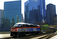
Metra train number 2707 on the Milwaukee District West route departs Chicago from Union Station using engine number 418, an MP36PH-3 locomotive.
Autor: Nate Beal, Licencja: CC BY 2.0
West Chicago, my fav photo location
Autor: User:S3raph,User:RedWordSmith,User:A435(m), Licencja: CC BY 2.5
The Chicago Metra commuter rail system. Map created by A435(m). Attribution required for all uses. <aristophanes2000@hotmail.com> made this image. As long as you retain this notice you can do whatever you want with this image, except. If we meet some day, and you think this image is worth it, you can buy me a beer in return.


