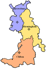
Metropolia Birmingham
 Mapa metropolii | |
| Państwo | |
|---|---|
| Kraj | |
| Siedziba | |
| Data powołania | 1911 |
| Metropolita | |
| Dane statystyczne | |
| Liczba diecezji | 3 |
Położenie na mapie Birmingham Contains Ordnance Survey data © Crown copyright and database right, CC BY-SA 3.0 | |
Położenie na mapie Wielkiej Brytanii (c) Karte: NordNordWest, Lizenz: Creative Commons by-sa-3.0 de | |
Położenie na mapie West Midlands Contains Ordnance Survey data © Crown copyright and database right, CC BY-SA 3.0 | |
Metropolia Birmingham – metropolia Kościoła rzymskokatolickiego, obejmująca trzy diecezje w zachodniej Anglii. Powstała 28 października 1911 roku. Najważniejszą świątynią metropolii jest katedra świętego Chada w Birmingham. Na czele metropolii stoi arcybiskup metropolita Birmingham. Od grudnia 2009 urząd metropolity sprawuje abp Bernard Longley.
Podział administracyjny
- archidiecezja Birmingham
- diecezja Clifton
- diecezja Shrewsbury
Bibliografia
Linki zewnętrzne
Media użyte na tej stronie
(c) Karte: NordNordWest, Lizenz: Creative Commons by-sa-3.0 de
Location map of the United Kingdom
Flag of England. Saint George's cross (a red cross on a white background), used as the Flag of England, the Italian city of Genoa and various other places.
Japanese map symbol "Church". U+26EA
Contains Ordnance Survey data © Crown copyright and database right, CC BY-SA 3.0
Map of the West Midlands, UK with the following information shown:
- Administrative borders
- Coastline, lakes and rivers
- Roads and railways
- Urban areas
Equirectangular map projection on WGS 84 datum, with N/S stretched 160%
Geographic limits:
- West: 2.22W
- East: 1.40W
- North: 52.68N
- South: 52.33N
Autor: self-created, Licencja: CC BY-SA 3.0
Catholic Province of Birmingham. This is a current map of the ecclesiastical province in the Catholic Church. The crosses mark where the current Cathedrals of each diocese is located. The specific dioceses are in different colours.
Contains Ordnance Survey data © Crown copyright and database right, CC BY-SA 3.0
Map of Birmingham, West Midlands, UK with electoral wards shown.
Equirectangular map projection on WGS 84 datum, with N/S stretched 160%
Geographic limits:
- West: 2.05W
- East: 1.72W
- North: 52.62N
- South: 52.37N


