Metropolia Hartford
| Państwo | |
|---|---|
| Stan | |
| Siedziba | |
| Data powołania | 1953 |
| Metropolita | |
| Dane statystyczne | |
| Liczba diecezji | 4 |
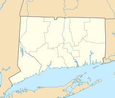
Metropolia Hartford – metropolia Kościoła rzymskokatolickiego obejmująca Fishers Island i północną część Long Island, oraz w całości stany Connecticut i Rhode Island w Stanach Zjednoczonych.
Katedrą metropolitarną jest katedra św. Józefa w Hartford.
Podział administracyjny
Metropolia jest częścią regionu[1] I (CT, MA, ME, NH, RI, VT)
Metropolici
- Henry J. O'Brien (1945–1969)
- John F. Whealon (1969–1991)
- Daniel Cronin (1992–2003)
- Henry Mansell (2003–2013)
- Leonard Blair (od 2013)
Przypisy
Bibliografia
- Hartford (Archdiocese) Catholic-Hierarchy. [dostęp 2010-03-01]. (ang.).
Linki zewnętrzne
Media użyte na tej stronie
Autor: Alexrk2, Licencja: CC BY 3.0
Ta mapa została stworzona za pomocą GeoTools.
Autor: Uwe Dedering, Licencja: CC BY-SA 3.0
Location map of the USA (without Hawaii and Alaska).
EquiDistantConicProjection:
Central parallel:
* N: 37.0° N
Central meridian:
* E: 96.0° W
Standard parallels:
* 1: 32.0° N
* 2: 42.0° N
Made with Natural Earth. Free vector and raster map data @ naturalearthdata.com.
Formulas for x and y:
x = 50.0 + 124.03149777329222 * ((1.9694462586094064-({{{2}}}* pi / 180))
      * sin(0.6010514667026994 * ({{{3}}} + 96) * pi / 180))
y = 50.0 + 1.6155950752393982 * 124.03149777329222 * 0.02613325650382181
      - 1.6155950752393982  * 124.03149777329222 *
     (1.3236744353715044  - (1.9694462586094064-({{{2}}}* pi / 180))
      * cos(0.6010514667026994 * ({{{3}}} + 96) * pi / 180))
The flag of Navassa Island is simply the United States flag. It does not have a "local" flag or "unofficial" flag; it is an uninhabited island. The version with a profile view was based on Flags of the World and as a fictional design has no status warranting a place on any Wiki. It was made up by a random person with no connection to the island, it has never flown on the island, and it has never received any sort of recognition or validation by any authority. The person quoted on that page has no authority to bestow a flag, "unofficial" or otherwise, on the island.
Japanese map symbol "Church". U+26EA
Autor: Closeapple, Licencja: CC-BY-SA-3.0
Geographical Latin rite Roman Catholic ecclesiastical provinces of the United States. Each of the 33 ecclesiastical provinces is a separate color. Eastern rite eparchies and dioceses are not shown.
Autor: AlexiusHoratius, Licencja: CC BY-SA 3.0
Map of the Catholic Archdiocese of Hartford in the USA.


