Metropolitan Borough of Sefton
| dystrykt metropolitalny | |
(c) Alexander P Kapp, CC BY-SA 2.0 Ratusz w Southport, jedna z siedzib władz hrabstwa | |
| Państwo | |
|---|---|
| Kraj | |
| Region | |
| Hrabstwo | |
| Siedziba | |
| Powierzchnia | 155 km² |
| Populacja (2016) • liczba ludności |
|
| • gęstość | 1769 os./km² |
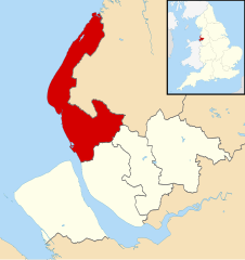
| Położenie na mapie Merseyside Contains Ordnance Survey data © Crown copyright and database right, CC BY-SA 3.0 | |
| Strona internetowa | |
| Portal | |
Metropolitan Borough of Sefton – dystrykt metropolitalny, leżący na terenie hrabstwa metropolitalnego Merseyside (aglomeracja Liverpool) na zachodnim wybrzeżu północnej Anglii, ok. 200 mil od Londynu, położony na północnym brzegu estuarium rzeki Mersey, przy jej ujściu do Morza Irlandzkiego (Liverpool Bay). Siedzibą zarządu okręgu jest miasto Bootle. Nazwa Sefton pochodzi od znajdującej się na obszarze okręgu wsi o tej samej nazwie. W skład okręgu wchodzą również: Aintree, Crosby, Formby, Maghull i Southport. Okręg Sefton graniczy bezpośrednio z miastem Liverpool i charakteryzuje się przede wszystkim przemysłem stoczniowym nad rzeką Mersey. Miastem partnerskim Sefton jest Gdańsk.
Sefton od 3 listopada 2005 dąży do uzyskania statusu terytorium Sprawiedliwego Handlu.
Miasta
Inne miejscowości
Ainsdale, Aintree, Birkdale, Blowick, Blundellsands, Brighton-le-Sands, Carr Houses, Churchtown, Crossens, Ford, Freshfield, Great Crosby, Highpark, Hightown, Ince Blundell, Kennessee Green, Kew, Lady Green, Litherland, Little Altcar, Little Crosby, Lunt, Lydiate, Marshside, Melling, Meols Cop, Netherton, Orrell, Seaforth, Sefton, Thornton, Waddicar, Waterloo, Woodvale.
Przypisy
- ↑ Population Estimates for UK, England and Wales, Scotland and Northern Ireland - Office for National Statistics, ons.gov.uk [dostęp 2017-10-21] (ang.).
Linki zewnętrzne
Media użyte na tej stronie
Flag of England. Saint George's cross (a red cross on a white background), used as the Flag of England, the Italian city of Genoa and various other places.
Contains Ordnance Survey data © Crown copyright and database right, CC BY-SA 3.0
Map of Merseyside, UK with Sefton highlighted.
Equirectangular map projection on WGS 84 datum, with N/S stretched 165%(c) Alexander P Kapp, CC BY-SA 2.0
This is a photo of listed building number 1379678.


