Mettupalayam
| ||
 | ||
| Państwo | ||
| Stan | Tamilnadu | |
| Dystrykt | Coimbatore | |
| Wysokość | 326 m n.p.m. | |
| Populacja (2001) • liczba ludności | 66 313 | |
| Nr kierunkowy | 91-4254 | |
| Kod pocztowy | 641301 | |
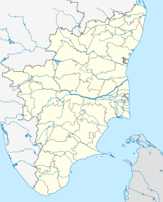
Położenie na mapie Indii | ||
Mettupalayam (tamilski: மேட்டுப்பாளையம்) – miasto w dystrykcie Coimbatore, w stanie Tamilnadu w Indiach, u podnóża gór Nilgiri, na wysokości 326 m n.p.m. W 2001 populacja miasta wyniosła 66 313[1]. Miasto jest znane głównie z linii kolejowej Nigiliri Mountain Railway do Utakamand, wpisanej na Listę Światowego Dziedzictwa UNESCO.
Przypisy
- ↑ www.censusindia.net (archiwum). [dostęp 2004-06-16]. [zarchiwizowane z tego adresu (2004-06-16)].
Media użyte na tej stronie
(c) Uwe Dedering z niemieckiej Wikipedii, CC BY-SA 3.0
Location map of India.
Equirectangular projection. Strechted by 106.0%. Geographic limits of the map:
- N: 37.5° N
- S: 5.0° N
- W: 67.0° E
- E: 99.0° E
The Flag of India. The colours are saffron, white and green. The navy blue wheel in the center of the flag has a diameter approximately the width of the white band and is called Ashoka's Dharma Chakra, with 24 spokes (after Ashoka, the Great). Each spoke depicts one hour of the day, portraying the prevalence of righteousness all 24 hours of it.
Autor: Maximilian Dörrbecker (Chumwa), Licencja: CC BY-SA 3.0
Location map of Tamil Nadu


