Mexicali
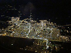
 Mexicali nocą | |||
| |||
| Dewiza: La ciudad que capturó al sol | |||
| Państwo | |||
|---|---|---|---|
| Stan | |||
| Data założenia | 1903 | ||
| Burmistrz | Gustavo Sánchez Vásquez | ||
| Powierzchnia | 637 km² | ||
| Wysokość | 20 m n.p.m. | ||
| Populacja (2010) • liczba ludności • gęstość |
| ||
| Kod pocztowy | 21000–21399 | ||
| Strona internetowa | |||
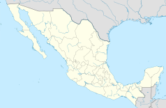
Mexicali – miasto w północnym Meksyku na granicy ze Stanami Zjednoczonymi, niedaleko miasta San Diego (USA). Stolica stanu Kalifornia Dolna (Baja California). W 2010 roku liczba mieszkańców miasta wyniosła blisko 690 tys. mieszkańców choć obszar metropolitarny liczył blisko 1,6 mln.
W mieście rozwinął się przemysł chemiczny, metalowy, włókienniczy, spożywczy oraz hutniczy[2]. Znajduje się tu port lotniczy, przygraniczna stacja kolejowa, dzielnica chińska la Chinesca, a nawet arena do korridy.
Współpraca
 Gumi, Korea Południowa
 Calexico, Stany Zjednoczone
 Puebla, Meksyk
 Jerez de la Frontera, Hiszpania
 São José dos Campos, Brazylia
 Las Vegas, Stany Zjednoczone
 Sacramento, Stany Zjednoczone
 San Luis Río Colorado, Meksyk
 El Centro, Stany Zjednoczone
 Yuma, Stany Zjednoczone
 Tecate, Meksyk
 Ensenada, Meksyk
 Adelaide, Australia
 Nankin, Chińska Republika Ludowa
 San Bernardino, Stany Zjednoczone
 Vancouver, Kanada
 Hermosillo, Meksyk
 Tijuana, Meksyk
 Navojoa, Meksyk
 Culiacán, Meksyk
 Szanghaj, Chińska Republika Ludowa
Przypisy
- ↑ Principales resultados por localidad 2010 (ITER) (hiszp.). Instituto Nacional de Estadística, Geografía e Informática.. [dostęp 2015-08-03].
- ↑ Mexicali, [w:] Encyklopedia PWN [online] [dostęp 2021-09-12].
Media użyte na tej stronie
The flag of Navassa Island is simply the United States flag. It does not have a "local" flag or "unofficial" flag; it is an uninhabited island. The version with a profile view was based on Flags of the World and as a fictional design has no status warranting a place on any Wiki. It was made up by a random person with no connection to the island, it has never flown on the island, and it has never received any sort of recognition or validation by any authority. The person quoted on that page has no authority to bestow a flag, "unofficial" or otherwise, on the island.
Autor: Pedro A. Gracia Fajardo, escudo de Manual de Imagen Institucional de la Administración General del Estado, Licencja: CC0
Flaga Hiszpanii
Coat of arms of Baja California
Autor: Addicted04, Licencja: CC BY-SA 4.0
Location map of Baja California.
EPSG:3857 projection, Geographic limits of the map:
- N: 33.04° N
- S: 27.54° N
- W: 118° W
- E: 112° W
Autor: ImageShack, Licencja: CC BY-SA 3.0
Mexicali metropolitan area showing the sister cities of Mexicali and Calexico. Calexico is in the foreground.


