Miasta Malty
Malta de facto jest państwem-miastem[1][2][3]. Malta oficjalnie nie posiada żadnych miast. Zgodnie z Konstytucją, jedynym elementem samorządu poniżej poziomu samej republiki jest system rad lokalnych (samorządów) nazywanych local council[4]. Państwo dzieli się na 68 local councils[5], każde z nich ma taki sam status.
W historii Malty istniało kilka miast. Tabela przedstawia historyczne miasta:
| Obecny local council | Dawne miasto | Rok uzyskania praw miejskich | Zdjęcie | Dodatkowe informacje |
|---|---|---|---|---|
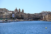
| Birgu | Città Vittoriosa | 1530[6] | © Plamen Agov • studiolemontree.com, CC BY-SA 3.0 | Stolica od 1530 do 1571 roku. Jedno z tzw. Three Cities. |
| Cospicua | Città Cospicua | 1722[7] |  | Jedno z tzw. Three Cities. |
| Mdina | Città Notabile Città Vecchia |  | De facto stolica od czasów antycznych do 1530 roku. | |
| Qormi | Città Pinto | 1743[8] |  | |
| Rabat (Victoria) | Città Victoria | 1887[9] |  | Główna miejscowość wyspy Gozo. Częścią jest Cittadella. |
| Senglea | Città Invicta | 1565[10] |  | Jedno z tzw. Three Cities. |
| Siġġiewi | Città Ferdinand | 1797[11] |  | |
| Valletta | Città Umilissima | 1571[12] | (c) Bengt Nyman, CC BY 3.0 | Obecna stolica Malty. |
| Żabbar | Città Hompesch | 1797[11] |  | |
| Żebbuġ | Città Rohan | 1777[13] |  | |
| Żejtun | Città Beland | 1797[11] |  |
Przypisy
- ↑ Department of Information of Malta: Flags, Symbols and their uses.
- ↑ Creativemalta.gov.mt: Draft National Strategy for the Cultural and Creative Industries – Creative Malta. [dostęp 2017-05-04]. [zarchiwizowane z tego adresu (2013-07-28)].
- ↑ „This very crowded isle: England is most over-populated country in EU” – Daily Mail.
- ↑ Division of Powers, Malta – portal.cor.europa.eu.
- ↑ About Local Government. lca.org.mt. [zarchiwizowane z tego adresu (2014-12-07)]. – Local Councils Association official page.
- ↑ Alfie Guillaumier: Bliet u Rħula Maltin. 1987, s. 41.
- ↑ Bormla (Città Cospicua).
- ↑ Vincent Zammit: Il-Gran Mastri - Ġabra ta' Tagħrif dwar l-Istorja ta' Malta fi Żmienhom - It-Tieni Volum 1680–1798. 1992, s. 427–428.
- ↑ The Conferment of The Title of City. [dostęp 2017-05-04]. [zarchiwizowane z tego adresu (2015-07-08)].
- ↑ Guillaumier (1987), p. 324
- ↑ a b c Zammit (1992), pp. 513–516
- ↑ Simon Gaul: Malta, Gozo & Comino. 2007, s. 100. ISBN 978-1-86011-365-9.
- ↑ The De Rohan Arch. Haz-Zebbug.com.
Media użyte na tej stronie
Autor: R Muscat, Licencja: CC BY-SA 2.0
Aerial view of the city of Mdina, Malta
Autor: Berthold Werner, Licencja: CC BY-SA 3.0
Malta, Gozo, Victoria
Autor: Oryginalnym przesyłającym był Helyman z angielskiej Wikipedii, Licencja: CC-BY-SA-3.0
Zejtun City Center
Qormi by night, seen from Marsa.
Autor: Frank Vincentz, Licencja: CC BY-SA 3.0
View from a Malta sightseeing two harbours cruise boat to Triq Santa Tereża and the Dockyard creek in Cospicua, Malta
Autor: Frank Vincentz, Licencja: CC BY-SA 3.0
View from Herbert Ganado Gardens in Floriana to The Spur and Senglea, Malta
© Plamen Agov • studiolemontree.com, CC BY-SA 3.0
View of Vittoriosa (Birgu) one of the so called „Three cities“ in Malta. The dome and the belfry of the Church of Annunciation can be seen.


