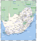
Miasta Południowej Afryki
W Republice Południowej Afryki nie funkcjonuje oficjalna, administracyjna definicja miasta. Największe obszary metropolitalne znajdują się w granicach okręgów metropolitalnych (ang. metropolitan municipalities). Pozostałe miasta, podobnie jak tereny wiejskie, podzielone są pomiędzy dystrykty (district municipalities), a następnie gminy (local municipalities).
Dla potrzeb statystycznych w kraju wprowadzono podział gmin na szereg kategorii odzwierciedlających stopień ich urbanizacji (podział ten nie jest jednak usankcjonowany prawnie). Gminy zdominowane przez zabudowę miejską są określane mianem „miast drugorzędnych” (secondary cities), natomiast gminy o mniejszym stopniu urbanizacji lecz z wyraźnie dostrzegalnym centrum zlokalizowanym na obszarze miejskim nazywane są „dużymi miasteczkami” (large towns). Pozostałe gminy przynależą do kategorii „małych miasteczek” (small towns) bądź „przeważająco wiejskich” (mostly rural)[1].
W 2011 roku w kraju było 8 okręgów metropolitalnych (oznaczanych literą A), 19 „miast drugorzędnych” (B1) oraz 29 „dużych miasteczek” (B2)[2].
Lista okręgów metropolitalnych (A) oraz gmin o dużym stopniu urbanizacji (kategorie B1 i B2)
Największe zespoły miejskie
Źródło: City Population
| L.p. | Aglomeracja | Prowincja | Liczba ludności (2011) |
|---|---|---|---|
| 1. | Johannesburg | Gauteng | 7 860 781 |
| 2. | Kapsztad | Przylądkowa Zachodnia | 3 430 992 |
| 3. | Durban | KwaZulu-Natal | 2 786 046 |
| 4. | Pretoria | Gauteng | 1 763 336 |
| 5. | Port Elizabeth | Przylądkowa Wschodnia | 876 436 |
| 6. | Soshanguve | Gauteng | 728 063 |
| 7. | Evaton | Gauteng | 605 504 |
| 8. | Pietermaritzburg | KwaZulu-Natal | 475 238 |
| 9. | Bloemfontein | Wolne Państwo | 464 591 |
| 10. | Vereeniging | Gauteng | 377 922 |
Alfabetyczna lista miejscowości
Źródło: World Gazetteer[4]
- Adelaide
- Alberton
- Alice
- Aliwal North
- Allanridge
- Atlantis
- Balfour
- Ballito
- Barberton
- Barkly West
- Beaufort West
- Bela Bela
- Benoni
- Bethal
- Bethlehem
- Bhisho
- Bloemfontein
- Bloemhof
- Boksburg
- Botshabelo
- Brakpan
- Brandfort
- Bredasdorp
- Breyten
- Brits
- Bronkhorstspruit
- Burgersdorp
- Carletonville
- Centurion
- Ceres
- Christiana
- Clarens
- Clocolan
- Colesberg
- Cradock
- Cullinan
- De Aar
- Delmas
- Deneysville
- Dewetsdorp
- Dundee
- Durban
- East London
- Empangeni
- Ermelo
- Eshowe
- Ficksburg
- Fochville
- Fort Beaufort
- Frankfort
- Ga-Rankuwa
- Gcuwa
- George
- Germiston
- Glencoe
- Graaff-Reinet
- Grabouw
- Greytown
- Groblershoop
- Harrismith
- Hartswater
- Heilbron
- Hennenman
- Hermanus
- Hoopstad
- Howick
- Jan Kempdorp
- Johannesburg
- Kapsztad
- Kathu
- Kempton Park
- Kenilworth
- Kimberley
- King William’s Town
- Klerksdorp
- Knysna
- Kokstad
- Komatipoort
- Kroonstad
- Krugersdorp
- Kuruman
- KwaDukuza
- KwaMhlanga
- Ladybrand
- Ladysmith
- Lebowakgomo
- Lephalale
- Lichtenburg
- Louis Trichardt
- Lydenburg
- Mabopane
- Mahikeng
- Mahwelereng
- Makhanda
- Malmesbury
- Margate
- Middelburg
- Middelburg
- Midrand
- Mmabatho
- Modimolle
- Modjadjiskloof
- Mokopane
- Montagu
- Mooi River
- Mossel Bay
- Mthatha
- Musina
- Nelspruit
- Newcastle
- Nigel
- Onseepkans
- Orkney
- Oudtshoorn
- Paarl
- Parys
- Phalaborwa
- Phuthaditjhaba
- Piet Retief
- Pietermaritzburg
- Polokwane
- Pongola
- Port Alfred
- Port Elizabeth
- Port Shepstone
- Postmasburg
- Potchefstroom
- Pretoria
- Prieska
- Queenstown
- Randburg
- Randfontein
- Randvaal
- Reitz
- Richards Bay
- Richmond
- Robertson
- Roodepoort
- Rustenburg
- Sandton
- Sasolburg
- Schweizer-Reneke
- Scottsburgh
- Secunda
- Senekal
- Simonstad
- Siyabuswa
- Somerset East
- Somerset West
- Soweto
- Springbok
- Springs
- Stellenbosch
- Stilfontein
- Stutterheim
- Swellendam
- Taung
- Tembisa
- Thaba Nchu
- Theunissen
- Thohoyandou
- Tzaneen
- Uitenhage
- Ulundi
- Umkomaas
- Upington
- Utrecht
- Vanderbijlpark
- Ventersdorp
- Vereeniging
- Victoria West
- Viljoenskroon
- Virginia
- Volksrust
- Vrede
- Vredefort
- Vredendal
- Vryburg
- Vryheid
- Warrenton
- Welkom
- Wellington
- Wilderness
- Winburg
- Witbank
- Worcester
Przypisy
- ↑ Delivering municipal services in rural areas (ang.). National Treasury. s. 193. [dostęp 2013-05-02].
- ↑ a b Municipal Capacity Assessment 2011 – National Trends in Municipal Capacity (ang.). Municipal Demarcation Board. [dostęp 2013-05-02].
- ↑ Table: Population per municipality (ang.). Statistics South Africa. [dostęp 2013-05-02].
- ↑ World Gazetteer (ang.)
Media użyte na tej stronie
(c) Kelisi z angielskojęzycznej Wikipedii, CC-BY-SA-3.0
A map showing South Africa's cities, main towns, selected villages, rivers, and its highest peak. This map's source is here, with the uploader's modifications, and the GMT homepage says that the tools are released under the GNU General Public License.


