Mid Sussex
| dystrykt niemetropolitalny | |
(c) Simon Carey, CC BY-SA 2.0 | |
| Państwo | |
|---|---|
| Kraj | |
| Region | |
| Hrabstwo | |
| Siedziba | |
| Powierzchnia | 334,02 km² |
| Populacja (2011) • liczba ludności |
|
| • gęstość | 420 os./km² |
| Położenie na mapie West Sussex Contains Ordnance Survey data © Crown copyright and database right, CC BY-SA 3.0 | |
| Strona internetowa | |
| Portal | |
Mid Sussex – dystrykt w hrabstwie West Sussex w Anglii. Znajdują się tam 3 miasta. Siedzibą dystryktu jest Haywards Heath, a największym miastem Burgess Hill. Trzecim miastem jest East Grinstead.
Inne miejscowości
Abbotsford, Albourne, Ansty, Ardingly, Ashurst Wood, Balcombe, Bolney, Clayton, Copthorne, Crawley Down, Cuckfield, Fulking, Goddards Green, Handcross, Hassocks, Hickstead, Horsted Keynes, Hurst Wickham, Hurstpierpoint, Keymer, Lindfield, Newtimber, Pease Pottage, Poynings, Pyecombe, Saddlescombe, Saint Hill Green, Sayers Common, Scaynes Hill, Sharpthorne, Slaugham, Staplefield, Turners Hill, Twineham, Warninglid, West Hoathly, Whitemans Green, Worth.
Media użyte na tej stronie
Flag of England. Saint George's cross (a red cross on a white background), used as the Flag of England, the Italian city of Genoa and various other places.
Contains Ordnance Survey data © Crown copyright and database right, CC BY-SA 3.0
Map of West Sussex, UK with Mid Sussex highlighted.
Equirectangular map projection on WGS 84 datum, with N/S stretched 155%(c) Simon Carey, CC BY-SA 2.0
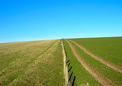
Boundary A physical and geographical boundary here, the fence marks the separation of the two fields as well as that of two district councils; Mid Sussex administers the land on the left and Lewes that on right. The footpath from Lower Standean to Keymer Post lies in the realm of MId Sussex.


