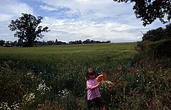
Mill Street
(c) Chris Heaton, CC BY-SA 2.0 | |
| Państwo | |
|---|---|
| Kraj | |
| Hrabstwo | Suffolk |
| Dystrykt | Babergh |
Położenie na mapie Suffolk Contains Ordnance Survey data © Crown copyright and database right, CC BY-SA 3.0 | |
Położenie na mapie Wielkiej Brytanii (c) Karte: NordNordWest, Lizenz: Creative Commons by-sa-3.0 de | |
| 51°59′57,5″N 0°53′42,3″E/51,999306 0,895083 | |
| Portal | |
Mill Street – przysiółek w Anglii, w hrabstwie Suffolk, w dystrykcie Babergh, w civil parish Polstead.[1]
Przypisy
- ↑ About Polstead, polstead.onesuffolk.net [dostęp 2017-11-18].
Linki zewnętrzne
Media użyte na tej stronie
Contains Ordnance Survey data © Crown copyright and database right, CC BY-SA 3.0
Map of Suffolk, UK with the following information shown:
- Administrative borders
- Coastline, lakes and rivers
- Roads and railways
- Urban areas
Equirectangular map projection on WGS 84 datum, with N/S stretched 160%
Geographic limits:
- West: 0.30E
- East: 1.90E
- North: 52.57N
- South: 51.92N
(c) Karte: NordNordWest, Lizenz: Creative Commons by-sa-3.0 de
Location map of the United Kingdom
Flag of England. Saint George's cross (a red cross on a white background), used as the Flag of England, the Italian city of Genoa and various other places.
(c) Chris Heaton, CC BY-SA 2.0
Floral delights in field at Mill Street. The summer of 1996 will be forever remembered by me as the year of red poppies. They seemed to be everywhere and lasted for many weeks.


