Millbridge (Devon)
| ||
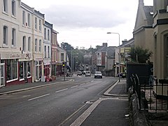
(c) Tony Atkin, CC BY-SA 2.0 | ||
| Państwo | ||
| Kraj | ||
| Region | South West England | |
| Hrabstwo ceremonialne | Devon | |
| Unitary authority | Plymouth | |
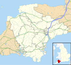
Położenie na mapie Devonu Contains Ordnance Survey data © Crown copyright and database right, CC BY-SA 3.0 | ||
| Strona internetowa | ||
| Portal | ||
Millbridge – dzielnica miasta Plymouth[1], w Anglii, w hrabstwie ceremonialnym Devon, w dystrykcie (unitary authority) Plymouth.
Przypisy
|
Media użyte na tej stronie
Flag of England. Saint George's cross (a red cross on a white background), used as the Flag of England, the Italian city of Genoa and various other places.
Contains Ordnance Survey data © Crown copyright and database right, CC BY-SA 3.0
Map of Devon, UK with the following information shown:
- Administrative borders
- Coastline, lakes and rivers
- Motorways and primary routes
- Urban areas
Equirectangular map projection on WGS 84 datum, with N/S stretched 150%
Geographic limits:
- West: 4.72W
- East: 2.86W
- North: 51.3N
- South: 50.16N
(c) Tony Atkin, CC BY-SA 2.0
Millbridge. This area of Plymouth is called Millbridge and is centred on this traffic light controlled crossroads. Around the crossroads can be found the usual local shops and services including a pub, mini-mart, take-away and several second-hand shops. The mill bridge after which this area is named was at the bottom of the hill on the road in the distance but the mills have long since vanished and the tidal creek the road crossed filled in to become a park 165188.
Autor: NordNordWest, Licencja: CC BY-SA 3.0
Location map of the United Kingdom


