Minot
 | |
| Państwo | |
|---|---|
| Stan | |
| Zarządzający | Shaun Sipma↗ |
| Powierzchnia | 37,7 km² |
| Populacja (2000) • liczba ludności • gęstość |
|
| Nr kierunkowy | 701 |
| Kod pocztowy | 58701 |
| Strona internetowa | |
| Portal | |
Minot – miasto w Stanach Zjednoczonych, w stanie Dakota Północna, w hrabstwie Ward, położone nad rzeką Souris. Ma 36 567 mieszkańców (2000) i jest czwartym co do wielkości miastem stanu.
Około 20 km na północ od miasta znajduje się wielka baza amerykańskich sił powietrznych, Minot Air Force Base, jedna z dwóch gdzie stacjonują bombowce B-52. W okolicach miasta rozmieszczone są też międzykontynentalne rakiety Minuteman III.
Urodził się tutaj amerykański raper i piosenkarz Wiz Khalifa.
Linki zewnętrzne
- Strona oficjalna. web.ci.minot.nd.us. [zarchiwizowane z tego adresu (2011-02-06)].
Media użyte na tej stronie
Autor: Uwe Dedering, Licencja: CC BY-SA 3.0
Location map of the USA (without Hawaii and Alaska).
EquiDistantConicProjection:
Central parallel:
* N: 37.0° N
Central meridian:
* E: 96.0° W
Standard parallels:
* 1: 32.0° N
* 2: 42.0° N
Made with Natural Earth. Free vector and raster map data @ naturalearthdata.com.
Formulas for x and y:
x = 50.0 + 124.03149777329222 * ((1.9694462586094064-({{{2}}}* pi / 180))
      * sin(0.6010514667026994 * ({{{3}}} + 96) * pi / 180))
y = 50.0 + 1.6155950752393982 * 124.03149777329222 * 0.02613325650382181
      - 1.6155950752393982  * 124.03149777329222 *
     (1.3236744353715044  - (1.9694462586094064-({{{2}}}* pi / 180))
      * cos(0.6010514667026994 * ({{{3}}} + 96) * pi / 180))
The flag of Navassa Island is simply the United States flag. It does not have a "local" flag or "unofficial" flag; it is an uninhabited island. The version with a profile view was based on Flags of the World and as a fictional design has no status warranting a place on any Wiki. It was made up by a random person with no connection to the island, it has never flown on the island, and it has never received any sort of recognition or validation by any authority. The person quoted on that page has no authority to bestow a flag, "unofficial" or otherwise, on the island.
Autor: Alexrk2, Licencja: CC BY 3.0
Ta mapa została stworzona za pomocą GeoTools.
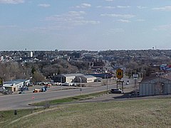
en:Minot, North Dakota, fr:Minot (Dakota du Nord) A view of Minot, North Dakota looking south from the slope of North Hill, just below the International Inn. The road shown in the photograph is Broadway, which takes more of the character of a highway than a street until it reaches the bottom of the hill. The downtown district is clearly visible in the centre-left. Minot State University is located at the bottom of the hill on the right; it is obscured by a Super 8 Motel and a beer billboard. The blue South Hill water tower can be seen on the horizon on the right. The older Rosehill water tower can be seen on the horizon on the left.


