Missisipi (rzeka)
 Rzeka Missisipi w stanie Iowa | |
| Kontynent | |
|---|---|
| Państwo | |
| Rzeka | |
| Długość | 3765,87[1] km |
| Powierzchnia zlewni | |
| Średni przepływ | 12 743 m³/s |
| Źródło | |
| Miejsce | jezioro Itasca[4], Hrabstwo Clearwater, Minnesota |
| Wysokość | 450 m n.p.m. |
| Współrzędne | |
| Ujście | |
| Recypient | |
| Miejsce | Pilottown[4] |
| Wysokość | 0 m n.p.m. |
| Współrzędne | |
| Mapa | |
 Mapa dorzecza Missisipi | |
Położenie na mapie Stanów Zjednoczonych  | |
Missisipi[5] (ang. Mississippi River) – druga pod względem długości rzeka w Ameryce Północnej, płynąca z północy na południe Stanów Zjednoczonych, o powierzchni dorzecza obejmującego około 3 mln km²[3][2]. Jej długość wynosi 3766 km (łącznie z rzekami Jefferson i Missouri 6275 km, co sprawia, że jest czwartą pod względem długości rzeką świata – po Nilu, Amazonce i Jangcy)[6].
Za początek rzeki uznawany jest jej wypływ z jeziora Itasca[4], leżącego na wysokości 447 m n.p.m.[7] w północnej części stanu Minnesota, w odległości około 120 km od granicy z Kanadą. Rzeka uchodzi do Zatoki Meksykańskiej deltą o trzech głównych ramionach.
Missisipi przepływa przez stany: Minnesota, Wisconsin, Iowa, Illinois, Missouri, Kentucky, Tennessee, Arkansas, Missisipi i Luizjana.
Do głównych dopływów Missisipi należą rzeki: Minnesota, Missouri, Arkansas i Red (prawostronne) oraz Tennessee i Ohio (lewostronne).
Część dorzecza Missisipi zajmuje obszar trzeciorzędowej zatoki morskiej. Dolina tej głównej rzeki jest żyzna, wypełniona osadami. Rzeka niesie ogromne ilości materiału, tworząc u ujścia rozległą deltę. Wysokie stany wód występują tu wiosną, w czasie topnienia śniegów oraz latem, gdy spadają duże deszcze. W wyniku wyniszczenia przez nieumiejętną gospodarkę człowieka wielkich obszarów leśnych i stepowych, zdarzają się na niej katastrofalne powodzie. W ostatnich latach, w związku z prowadzeniem racjonalnej gospodarki rolnej (np. orki wstęgowej), ilość niesionych namułów uległa znacznemu zmniejszeniu.
Większe miasta nad rzeką to: Minneapolis, Saint Paul, Davenport, Saint Louis, Memphis, Baton Rouge i Nowy Orlean.
Nad rzeką Missisipi amerykański pisarz Mark Twain umieścił akcję swoich dwóch powieści: Przygody Tomka Sawyera oraz Przygody Hucka Finna.
 (c) Johnny Q, CC BY 3.0
Rzeka Missisipi w Minneapolis
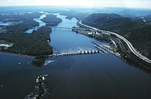
Zapora i most na rzece Missisipi nieopodal miasta La Crosse (stan Wisconsin)

Rzeka Missisipi w Nowym Orleanie

Delta Missisipi na zdjęciu satelitarnym
Zobacz też
Przypisy
- ↑ Lengths of major rivers, from USGS Water-Science School. water.usgs.gov. [dostęp 2015-10-21]. (ang.).
- ↑ a b Kammerer, J.C.: Largest Rivers in the United States. U.S. Geological Survey. [dostęp 2014-12-23]. (ang.).
- ↑ a b Mississippi River, [w:] Encyclopædia Britannica [online] [dostęp 2014-12-23] (ang.).
- ↑ a b c Feature Detail Report for: Mississippi River. US Geographic Names Information System, U.S. Geological Survey. [dostęp 2014-12-23]. (ang.).
- ↑ Komisja Standaryzacji Nazw Geograficznych poza Granicami RP: Nazewnictwo Geograficzne Świata. T. Zeszyt 1: Ameryka, Australia i Oceania. Warszawa: Główny Urząd Geodezji i Kartografii, 2004, s. 87. ISBN 83-239-7552-3.
- ↑ Matt Williams: What are the Longest Rivers In the World?. universetoday.com, 3 czerwca 2015. [dostęp 2015-10-21]. (ang.).
- ↑ Feature Detail Report for: Lake Itasca. US Geographic Names Information System, U.S. Geological Survey. [dostęp 2014-12-23]. (ang.).
Media użyte na tej stronie

The flag of Navassa Island is simply the United States flag. It does not have a "local" flag or "unofficial" flag; it is an uninhabited island. The version with a profile view was based on Flags of the World and as a fictional design has no status warranting a place on any Wiki. It was made up by a random person with no connection to the island, it has never flown on the island, and it has never received any sort of recognition or validation by any authority. The person quoted on that page has no authority to bestow a flag, "unofficial" or otherwise, on the island.
Autor: Shannon1, Licencja: CC BY-SA 4.0
A more accurate Map of the Mississippi River Basin, intended to replace File:Mississippirivermapnew.jpg. Made using USGS data.

Autor: Autor nie został podany w rozpoznawalny automatycznie sposób. Założono, że to PRA (w oparciu o szablon praw autorskich)., Licencja: CC-BY-SA-3.0
Mississippi River - New Orleans (Louisiana) self made PRA
- Algiers Point is seen at right. Across the River is the East Bank of New Orleans. At far left is the lower edge of the French Quarter with the Old Mint building visible. Going down river to the right, are the Marigny and Bywater neighborhoods of New Orleans, with the Naval Support Facility beside the Industrial Canal entrance being the large complex of buildings just across the river at the right edge of the photo. Parts of the Industrial Canal can be seen perpendicular to the River, with the Mississippi River-Gulf Outlet Canal paralleling the river to the top of the photo. In the distance at top left, Lake Pontchartrain.

Mississippi River Delta from space. This image was acquired on May 24, 2001 by the Advanced Spaceborne Thermal Emission and Reflection Radiometer (ASTER) on NASA's Terra satellite. Hurricanes Katrina and Rita destroyed much of the Mississippi River Delta in 2005.

(c) Johnny Q, CC BY 3.0
Drone shot of the Mississippi River, Nicollet Island, St. Anthony Falls, various East Bank neighborhoods. Closest bridge is Hennepin Avenue Bridge; downsteam are Central Avenue Bridge, Stone Arch Bridge, and I-35W Saint Anthony Falls Bridge.
Mississippi River from Fire Point in Effigy Mounds National Monument, Iowa, USA
Autor: Uwe Dedering, Licencja: CC BY-SA 3.0
Relief location map of the USA (without Hawaii and Alaska).
EquiDistantConicProjection : Central parallel :
* N: 37.0° N
Central meridian :
* E: 96.0° W
Standard parallels:
* 1: 32.0° N
* 2: 42.0° N
Made with Natural Earth. Free vector and raster map data @ naturalearthdata.com.
Formulas for x and y:
x = 50.0 + 124.03149777329222 * ((1.9694462586094064-({{{2}}}* pi / 180))
      * sin(0.6010514667026994 * ({{{3}}} + 96) * pi / 180))
y = 50.0 + 1.6155950752393982 * 124.03149777329222 * 0.02613325650382181
      - 1.6155950752393982  * 124.03149777329222 *
     (1.3236744353715044  - (1.9694462586094064-({{{2}}}* pi / 180))
      * cos(0.6010514667026994 * ({{{3}}} + 96) * pi / 180))

Mississippi River Lock and Dam number 7 with the I-90 Mississippi River bridge downstream.