Mobile (rzeka)
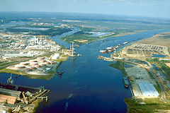
 Rzeka Mobile w końcowym biegu, w miejscu gdzie uchodzi do niej Chickasaw Creek | |
| Kontynent | |
|---|---|
| Państwo | |
| Stan | |
| Długość | 72 km |
| Powierzchnia zlewni | 114 000 km² |
| Źródło | |
| Miejsce | zbieg rzek Alabama i Tombigbee |
| Wysokość | 2 m n.p.m. |
| Współrzędne | |
| Ujście | |
| Recypient | zatoka Mobile (Zatoka Meksykańska) |
| Miejsce | koło miasta Mobile |
| Współrzędne | |
| Mapa | |
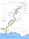
 Rzeka Mobile i jej dopływy | |
Mobile (ang. Mobile River) – rzeka w Stanach Zjednoczonych, w południowo-zachodniej części stanu Alabama. Długość rzeki wynosi 72 km, a powierzchnia dorzecza – 114 000 km²[1].
Rzeka Mobile powstaje z połączenia rzek Alabama i Tombigbee, na wysokości 2 m n.p.m.[2] Płynie w kierunku południowym, otoczona przez tereny podmokłe, stanowiąc część rozległej delty rzecznej. Niemal na całej długości równolegle do Mobile, na wschód od niej, biegnie jej odnoga – rzeka Tensaw. Uchodzi do zatoki Mobile (część Zatoki Meksykańskiej). Nad jej ujściem, na zachodnim brzegu położone jest miasto portowe Mobile[1][2].
Przypisy
- ↑ a b Mobile River, [w:] Encyclopædia Britannica [online] [dostęp 2021-10-02] (ang.).
- ↑ a b TopoView, USGS [dostęp 2021-10-02] (ang.).
Media użyte na tej stronie
Autor: Uwe Dedering, Licencja: CC BY-SA 3.0
Relief location map of the USA (without Hawaii and Alaska).
EquiDistantConicProjection : Central parallel :
* N: 37.0° N
Central meridian :
* E: 96.0° W
Standard parallels:
* 1: 32.0° N
* 2: 42.0° N
Made with Natural Earth. Free vector and raster map data @ naturalearthdata.com.
Formulas for x and y:
x = 50.0 + 124.03149777329222 * ((1.9694462586094064-({{{2}}}* pi / 180))
      * sin(0.6010514667026994 * ({{{3}}} + 96) * pi / 180))
y = 50.0 + 1.6155950752393982 * 124.03149777329222 * 0.02613325650382181
      - 1.6155950752393982  * 124.03149777329222 *
     (1.3236744353715044  - (1.9694462586094064-({{{2}}}* pi / 180))
      * cos(0.6010514667026994 * ({{{3}}} + 96) * pi / 180))
The flag of Navassa Island is simply the United States flag. It does not have a "local" flag or "unofficial" flag; it is an uninhabited island. The version with a profile view was based on Flags of the World and as a fictional design has no status warranting a place on any Wiki. It was made up by a random person with no connection to the island, it has never flown on the island, and it has never received any sort of recognition or validation by any authority. The person quoted on that page has no authority to bestow a flag, "unofficial" or otherwise, on the island.
Autor: SANtosito, Licencja: CC BY-SA 4.0
Relief location map of Alabama, USA
Geographic limits of the map:
- N: 35.2° N
- S: 29.9° N
- W: 88.7° W
- E: 84.7° W
Aerial view of the Mobile River at its confluence with Chickasaw Creek, about 5 miles (8 km) above the river's mouth in Mobile Bay at Mobile, Alabama. The city of Chickasaw, Alabama, is visible at the upper-left corner of the photograph. The Cochrane–Africatown bridge, carrying U.S. Route 90, was under construction at the time this photograph was taken. The piers that support the bridge can be seen standing on either side of the river and a tall construction crane is visible. The bridge was opened in 1991.
Autor:
- Original: Pfly, using a base map template made with US Federal public domain GIS data;
- Version 3: John Lambert
Map showing the Mobile-Alabama-Coosa River for use on wikipedia pages about those rivers, which currently have poor or no maps. Also intended to show how the main river changes its name several times. Style inspired by the Commons image "Rhein-Karte.png". Revised earlier version to make tones darker. Revised to correct the position of Rome, Georgia.


