Mohawk (rzeka)
 Wodospad na rzece Mohawk | ||||||||||||||||
| Kontynent | ||||||||||||||||
|---|---|---|---|---|---|---|---|---|---|---|---|---|---|---|---|---|
| Państwo | ||||||||||||||||
| Rzeka | ||||||||||||||||
| Długość | 230 km | |||||||||||||||
| Powierzchnia zlewni | 8960,9[1] km² | |||||||||||||||
| Źródło | ||||||||||||||||
| Wysokość | 280 m n.p.m. | |||||||||||||||
| Współrzędne | ||||||||||||||||
| Ujście | ||||||||||||||||
| Recypient | rzeka Hudson | |||||||||||||||
| Miejsce | Hudson | |||||||||||||||
| Wysokość | 3 m n.p.m.[2] | |||||||||||||||
| Współrzędne | ||||||||||||||||
| Mapa | ||||||||||||||||
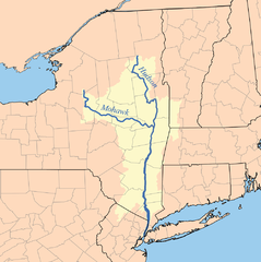
 Rzeki Mohawk i Hudson | ||||||||||||||||
| Szlak | ||||||||||||||||
| ||||||||||||||||
Mohawk (ang Mohawk River) – rzeka we wschodniej części Stanów Zjednoczonych, w stanie Nowy Jork. Jest najważniejszym dopływem rzeki Hudson, której dostarcza około 25% wody[1]. Długość rzeki wynosi około 230 km, a powierzchnia dorzecza blisko 9 tys. km². Na rzece zbudowano trzy zbiorniki retencyjne: Hinckley Reservoir, Delta Reservoir oraz Schoharie Reservoir[1].
Mohawk odegrała ważną rolę historyczną jako szlak wodny prowadzący w głąb kontynentu w XVIII i XIX wieku.
Zobacz też
Przypisy
- ↑ a b c d Mohawk River, Mohawk River Basin Program. New York State Department of Environmental Conservation. [dostęp 2014-12-07]. (ang.).
- ↑ Feature Detail Report for: Mohawk River
Media użyte na tej stronie
The flag of Navassa Island is simply the United States flag. It does not have a "local" flag or "unofficial" flag; it is an uninhabited island. The version with a profile view was based on Flags of the World and as a fictional design has no status warranting a place on any Wiki. It was made up by a random person with no connection to the island, it has never flown on the island, and it has never received any sort of recognition or validation by any authority. The person quoted on that page has no authority to bestow a flag, "unofficial" or otherwise, on the island.
Autor: UpstateNYer, Licencja: CC BY-SA 3.0
Cohoes Falls on the Mohawk River in Cohoes, New York, during winter, but after a warm spell, which caused local melting, adding to the typical seasonal flow of the river.
Autor: Uwe Dedering, Licencja: CC BY-SA 3.0
Relief location map of the USA (without Hawaii and Alaska).
EquiDistantConicProjection : Central parallel :
* N: 37.0° N
Central meridian :
* E: 96.0° W
Standard parallels:
* 1: 32.0° N
* 2: 42.0° N
Made with Natural Earth. Free vector and raster map data @ naturalearthdata.com.
Formulas for x and y:
x = 50.0 + 124.03149777329222 * ((1.9694462586094064-({{{2}}}* pi / 180))
      * sin(0.6010514667026994 * ({{{3}}} + 96) * pi / 180))
y = 50.0 + 1.6155950752393982 * 124.03149777329222 * 0.02613325650382181
      - 1.6155950752393982  * 124.03149777329222 *
     (1.3236744353715044  - (1.9694462586094064-({{{2}}}* pi / 180))
      * cos(0.6010514667026994 * ({{{3}}} + 96) * pi / 180))
Autor: Autor nie został podany w rozpoznawalny automatycznie sposób. Założono, że to Kmusser (w oparciu o szablon praw autorskich)., Licencja: CC BY-SA 3.0
This is a map of the Hudson River Watershed I made using USGS data, includes the Mohawk River.


