Molopo
| ||
| Kontynent | Afryka | |
| Państwo | ||
| Rzeka okresowa | ||
| Długość | ok. 1000 km | |
| Źródło | ||
| Miejsce | wyżyna Środkowego Weldu | |
| Współrzędne | 25°53′08″S 26°01′27″E/-25,885556 26,024167 | |
| Ujście | ||
| Recypient | Oranje | |
| Współrzędne | 28°31′02″S 20°12′46″E/-28,517222 20,212778 | |
Molopo - rzeka okresowa w Południowej Afryce i Botswanie, prawy dopływ Oranje; długość około 1000 km; źródła na wyżynie Środkowego Weldu (RPA); po letnich opadach prowadzi niewielkie ilości wody, zimą wysycha.
Media użyte na tej stronie
(c) The National Archives UK, OGL v1.0
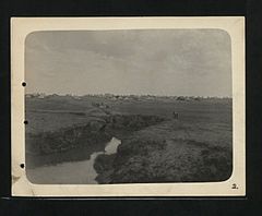
Description: Mafeking Burgher Camp. Trenches draining into Moloppo River. Arrangement of Tentes.
Our Catalogue Reference: Part of CO 1069/215
This image is part of the Colonial Office photographic collection held at The National Archives, uploaded as part of the Africa Through a Lens project. Feel free to share it within the spirit of the Commons.Autor:
- File:South Africa location map.svg by NordNordWest
- derivative work by Htonl
Relief location map of South Africa
Equirectangular projection, N/S stretching 110 %. Geographic limits of the map:
- N: 21.8° S
- S: 35.2° S
- W: 16.0° E
- E: 33.2° E


