Monongahela River
| Ten artykuł od 2014-04 wymaga zweryfikowania podanych informacji. |
| ||
 Mapa rzeki Monongahela | ||
| Kontynent | Ameryka Północna | |
|---|---|---|
| Państwo | ||
| Rzeka | ||
| Długość | 206 km | |
| Powierzchnia zlewni | 19011 km² | |
| Średni przepływ | 358 m³/s Braddock | |
| Źródło | ||
| Współrzędne | 39°27′53″N 80°09′10″W/39,464722 -80,152778 | |
| Ujście | ||
| Recypient | rzeka Ohio | |
| Miejsce | Pittsburgh, Pensylwania | |
| Wysokość | 216 m n.p.m. | |
| Współrzędne | 40°26′30″N 80°00′58″W/40,441667 -80,016111 | |
Monongahela (ang. Monongahela River) – rzeka w amerykańskich stanach Wirginia Zachodnia i Pensylwania. Bierze początek w stanie Wirginia Zachodnia z połączenia rzek Tygart Valley i West Fork. W Pittsburghu łączy się z rzeką Allegheny dając początek rzece Ohio. Jej długość wynosi 206 km.
Zobacz też
Linki zewnętrzne

Media użyte na tej stronie
Autor: Uwe Dedering, Licencja: CC BY-SA 3.0
Relief location map of the USA (without Hawaii and Alaska).
EquiDistantConicProjection : Central parallel :
* N: 37.0° N
Central meridian :
* E: 96.0° W
Standard parallels:
* 1: 32.0° N
* 2: 42.0° N
Made with Natural Earth. Free vector and raster map data @ naturalearthdata.com.
Formulas for x and y:
x = 50.0 + 124.03149777329222 * ((1.9694462586094064-({{{2}}}* pi / 180))
      * sin(0.6010514667026994 * ({{{3}}} + 96) * pi / 180))
y = 50.0 + 1.6155950752393982 * 124.03149777329222 * 0.02613325650382181
      - 1.6155950752393982  * 124.03149777329222 *
     (1.3236744353715044  - (1.9694462586094064-({{{2}}}* pi / 180))
      * cos(0.6010514667026994 * ({{{3}}} + 96) * pi / 180))
The flag of Navassa Island is simply the United States flag. It does not have a "local" flag or "unofficial" flag; it is an uninhabited island. The version with a profile view was based on Flags of the World and as a fictional design has no status warranting a place on any Wiki. It was made up by a random person with no connection to the island, it has never flown on the island, and it has never received any sort of recognition or validation by any authority. The person quoted on that page has no authority to bestow a flag, "unofficial" or otherwise, on the island.
Autor: Tim Kiser (w:User:Malepheasant), Licencja: CC BY-SA 2.5
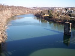
The w:Monongahela River in w:Fairmont, West Virginia
Autor: Pfly, Licencja: CC BY-SA 2.5
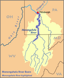
This is a map of the Monongahela River basin, with the Monongahela River in West Virginia and Pennsylvania highlighted.
- Credits


