Mons Agnes
| ||
 Mons Agnes | ||
| Ciało niebieskie | Księżyc | |
| Wysokość | 30 m nad poziom odniesienia | |
Mons Agnes – góra w północnej części widocznej strony Księżyca. Jej współrzędne selenograficzne wynoszą ☾ 18,6°N 5,3°E/18,600000 5,300000, a średnica tylko 0,65 km. Leży na Jeziorze Szczęścia na północ od Morza Oparów, nieco na południowy wschód od dużego łańcucha górskiego Montes Apenninus. Nazwa, nadana w 1979 roku pochodzi od greckiego imienia żeńskiego Agnieszka.
Zobacz też
Linki zewnętrzne
- Interaktywna mapa
- NASA lunar topophotomap (based on Apollo 15 photos)
- Mons Agnes in Gazetteer of Planetary Nomenclature
Media użyte na tej stronie
Black up-pointing triangle ▲, U+25B2 from Unicode-Block Geometric Shapes (25A0–25FF)
Autor:
- Nuvola_apps_kmoon.png: David Vignoni / derivative work: Lady Whistler (talk)
Icon from Nuvola icon theme for KDE 3.x.
A hill named Mons Agnes on the Moon, in Lacus Felicitatis, in crater-like feature Ina (a map). Centered at 18.65°N, 5.33°E. Photo by Lunar Reconnaissance Orbiter, made with Narrow Angle Camera 24 December 2009 from altitude 45 km. Sun elevation is 6.6°.
Width of the photo is 1.0 km, north is up.
cylindrical map projection of the Moon. The Moon's whole surface was mapped by the Clementine spacecraft in 1994, here North is at the top. The dark floor of crater Plato is at the middle top above Mare Imbrium, while the bright floor and rays of crater Tycho is near the middle bottom below Mare Imbrium. Mare Procellarum is at the near left, and Mare Tranquillitatis is just right of centre and Mare Crisium is at the near right. The far left and far right show the contrast of the mostly cratered farside with small isolated mare.
(c) Luc Viatour, CC-BY-SA-3.0
Nearly Full Moon view from earth In Belgium (Hamois).
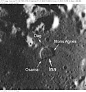
Moon craters Ina, Dag, Osama and Mons Agnes. Detail from Apollo 17 metric image AS17-M-1518, remapped to a north-up aerial view by LTVT.


