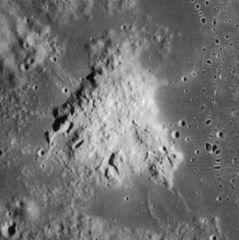
Mons Hansteen
| ||
 | ||
| Ciało niebieskie | Księżyc | |
| Położenie | południowy brzeg Oceanus Procellarum | |
| Wysokość | 1000 m nad poziom odniesienia | |
Mons Hansteen – niewielka góra w południowo-zachodniej części widocznej strony Księżyca, na południowej krawędzi Oceanus Procellarum (Oceanu Burz), znana również jako Hansteen Alfa (α).
Mons Hansteen była pierwotnie wulkanem. Jej podstawa w przybliżeniu ma kształt trójkąta, którego najdłuższa, wschodnia krawędź ma długość około 30 km. Nazwa pochodzi od leżącego na zachód od niej krateru Hansteen, który upamiętnia norweskiego fizyka i astronoma Christophera Hansteena (1784-1873). Na południe od góry leży krater Billy.
Zobacz też
Bibliografia
- Antonín Rükl: Mondatlas. Praga 1990.
Media użyte na tej stronie
Black up-pointing triangle ▲, U+25B2 from Unicode-Block Geometric Shapes (25A0–25FF)
Autor:
- Nuvola_apps_kmoon.png: David Vignoni / derivative work: Lady Whistler (talk)
Icon from Nuvola icon theme for KDE 3.x.
cylindrical map projection of the Moon. The Moon's whole surface was mapped by the Clementine spacecraft in 1994, here North is at the top. The dark floor of crater Plato is at the middle top above Mare Imbrium, while the bright floor and rays of crater Tycho is near the middle bottom below Mare Imbrium. Mare Procellarum is at the near left, and Mare Tranquillitatis is just right of centre and Mare Crisium is at the near right. The far left and far right show the contrast of the mostly cratered farside with small isolated mare.
(c) Luc Viatour, CC-BY-SA-3.0
Nearly Full Moon view from earth In Belgium (Hamois).
Autor: James Stuby based on NASA image
, Licencja: CC0
Mons Hansteen, on the moon.


